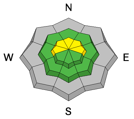
Forecast for the Logan Area Mountains

Toby Weed
Issued by Toby Weed for
Sunday, November 27, 2016

Expect a rising avalanche danger during the storm as snow accumulates and is drifted onto steep upper elevation slopes. Wind slab and persistent slab avalanches are possible at upper elevations in drifted terrain and on smooth north facing slopes with preexisting snow. The danger of storm snow avalanches will increase with significant accumulations and continuing wind.

  • Very shallow early season snow cover exists in the backcountry, and hitting rocks is perhaps still more a concern than potential avalanche danger.
  • You don't want to take a ride even in a small avalanche, as you could easily be injured with the shallow snow hardly covering up the rocks and dead-fall in avalanche runout zones.
Low
Moderate
Considerable
High
Extreme
Learn how to read the forecast here
Special Announcements

USU Outdoor Program is hosting a free Know Before You Go Avalanche Awareness talk on Wednesday night, 11-30-2016. more info go.. HERE

You are invited to our annual Pray for Snow fundraiser/party on Wednesday December 7 at the Italian Place in downtown Logan. For tickets and information Go...HERE


Fresh from Canada.....

Check out the story HERE

Weather and Snow

Expect to find very shallow early season conditions, with all but due north facing slopes completely bare of snow before last week. There's only a few inches covering the rocks up at Tony Grove, and 9 inches of total snow on the ground at 8200' at the Franklin Basin Snotel just north of the state line. It's 19 degrees this morning at 9700' on Logan Peak, with sustained 30 mph+ winds overnight from the south-southeast, with gusts pushing 50 mph.

Remember, the Tony Grove Road is a busy shared use area, so you have to watch your speed around pedestrians and dogs. The road is not maintained for driving in the winter, so if you attempt the drive in your 4x4, be prepaired with shovel and winter survival gear...


The early season is a great time to refresh yourself and practice companion rescue techniques with your partners.

Recent Avalanches

A party in the Tony Grove Area reported some subtle audible collapsing in north facing terrain at around 9000' on Thanksgiving Day. No avalanches were reported locally, but a skier triggered avalanche and a small natural avalanche cycle occurred this week at upper elevations in the Central Wasatch Range...

Ad
Avalanche Problem #1
Wind Drifted Snow
Type
Location
Likelihood
Size
Description

Drifting snow from strong and sustained south winds in the past couple days and overnight created potential for wind slab avalanches in lee terrain at upper elevations.

Avalanche Problem #2
Persistent Weak Layer
Type
Location
Likelihood
Size
Description

Small persistent slab avalanches may be possible on slopes with preexisting weak faceted snow near the ground. Potential is limited to smooth north facing slopes at the highest elevations.

Avalanche Problem #3
New Snow
Type
Location
Likelihood
Size
Description

Expect a rising danger as significant snow accumulates and is drifted on steep slopes in the next couple days.

Additional Information

The National Weather Service has issued a Winter Storm Warning for the mountains of Northern Utah. A series of increasingly cold Pacific storm systems will cross the area beginning late tonight and continuing on into Tuesday. Here's the latest NWS briefing;

General Announcements

Between now and Jan 15th: Donate to the Utah Avalanche Center by shopping at Whole Foods Market Utah! When you visit any Utah Whole Foods Market locations, bring your re-usable bags, Whole Foods will donate a dime per bag to the Utah Avalanche Center - if you say DONATE my bag credit.

Remember your information can save lives. If you see anything we should know about, please help us out by submitting snow and avalanche conditions. You can also call us at 801-524-5304, email by clicking HERE, or include #utavy in your tweet or Instagram.