BOTTOM LINE
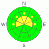
Danger by aspect and elevation on slopes approaching 35° or steeper.
(click HERE for tomorrow's danger rating)
|

Danger Rose Tutorial
|
In the wind zone above treeline, pockets of Level 2 (MODERATE) avalanche danger exist on steep, wind loaded, leeward slopes and human triggered avalanches are possible.
Out of the wind a Level 1 (LOW) avalanche danger exists. |
|
|
CURRENT CONDITIONS |

|
Skies are partly cloudy and temperatures are in the low to mid 30’s. South and southwest winds increased midday Tuesday and have been blowing in the 30’s and 40’s along the high ridges. Monday night’s storm delivered 4”-6” of new snow, barely covering up the hard, old, molar rattling tracks.
|
|
|
RECENT ACTIVITY |

|
No new avalanche activity to report.
Click here to view recent observations. |
|
|
THREAT #1 |

|
| WHERE |
PROBABILITY |
SIZE |
TREND |
|
|
|
|
| |
|
|
Over the next
24 hours.
|
|
|
The cold front that raced through the state on Monday helped knock temperatures down into the teens and essentially welded the snowpack in place. The avalanche danger for most of the terrain throughout the region is pretty straight forward and benign. However, if you’re getting into the wind zone be aware of fresh wind drifts along the leeward side of upper elevation ridges and around terrain features like chutes and gullies. |
|
|
MOUNTAIN WEATHER |

|
A weak storm system moves through the region tonight, cooling temperatures and bringing light snow to the area. Southwest winds will be a nuisance, blowing in the 30’s and 40’s, switching to the northwest and decreasing late tonight. High temperatures climb into the 40’s and dive into the 20’s this evening. A dry and warm westerly flow develops for Thursday and Friday. Southwest winds increase Saturday ahead of a good looking storm slated to impact the region late Saturday and Sunday. |
|
|
GENERAL ANNOUNCEMENTS |
The information in this advisory expires 24 hours after the date and time posted, but will be updated by 7:00 AM Saturday, March 31st.
If you’re getting out and about and trigger an avalanche or see anything interesting please drop me an email at
craig@utahavalanchecenter.org
or call 801-231-2170 |
|
|
This information does not apply to developed ski areas or highways where avalanche control is normally done. This advisory is from the U.S.D.A. Forest Service, which is solely responsible for its content. This advisory describes general avalanche conditions and local variations always occur. |
|
This advisory provided by the USDA Forest Service, in partnership with:
The Friends of the Utah Avalanche Center, Utah Division of State Parks and Recreation, Utah Division of Emergency Management, Salt Lake County, Salt Lake Unified Fire Authority and the friends of the La Sal Avalanche Center. See our Sponsors Page for a complete list. |
