BOTTOM LINE
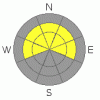
Danger by aspect and elevation on slopes approaching 35° or steeper.
(click HERE for tomorrow's danger rating)
|

Danger Rose Tutorial
|
At and above treeline we're dealing with a tale of two slabs created by the wind, one hard, one soft. This makes for an overall Level 2 (Moderate) danger with pockets of Level 3 (Considerable) danger on slopes that face NW, N, NE & E. This danger is most pronounced in steep rocky locations.
Our deep slab issue hasn't gone away. There is a Level 2 (Moderate) hazard associated with this persistent trouble maker. While the chances of triggering a deep slab avalanche are low, the consequences are very high if you do.
Last, be sure to give the monster cornices a wide berth. These things have the potential to break off at any time, and this afternoon's warm temperatures will only accelerate the process. |
|
|
CURRENT CONDITIONS |

|
The wind has finally died down after a very blustery 48 hours. Winds were out of the S, SE & SW at an average of 45 mph, gusting as high as 70 mph over the last two days. Needless to say, there is a lot of wind affected snow in the region.
Great sledding & skiing conditions can be found in sheltered areas where the 10" or so of new snow is riding very nicely. Temps are crisp this morning throughout the Uintas with the mercury reading in the single digits at and above treeline. Temps are a few degrees warmer at lower elevations. Winds are well behaved right now, blowing out of the SW @ 15 mph. |
|
|
RECENT ACTIVITY |

|
Sensitive wind slabs ranging from 6" to 24" in depth were the main cause for concern yesterday. These touchy wind slabs were easily triggered with ski cuts and cornice drops. Check out this great example from Ted yesterday. |
|
|
THREAT #1 |

|
| WHERE |
PROBABILITY |
SIZE |
TREND |

|
|
|
|
| |
|
|
Over the next
24 hours.
|
|
|
I'm covering two hazards under this banner this morning.
1. The first wind slab is the obvious one. This is the soft slab on the snow surface that went through a natural cycle early yesterday morning and was then very sensitive to human poking & prodding in the afternoon. These windslabs should be settling out rapidly. For the most part, this is a manageable hazard that can be found at & above treeline on slopes 35° & steeper today.
2. As Craig Gordon says, “We're got to be aware not only of the snow were riding in, but also the snow were riding on.” Yesterday Craig & I were looking to see what kind of damage the recent big winds had done. The answer can be found by digging down into the snow that feels so solid under our machines & skis. What we found was a hard slab, about 16" in depth that fails in a sickeningly planer fashion, meaning it's got a lot of stored energy in it. Check out this great example in this video. These kinds of conditions catch riders off guard because this hard snow feels strong. But, we can’t mistake strength for stability. It's a hard slab, so it's made of some very strong snow, but it is not stable, in fact it's reactive to a light/medium trigger. This slightly deeper hard slab has the potential to cause some destruction. You're most likely to get into a tangle with this thing in steep terrain above treeline on slopes facing E, NE, N & NW. It is easily avoidable however, by sticking to lower angle slopes at and below treeline, where the riding will be better too. |
|
|
THREAT #2 |

|
| WHERE |
PROBABILITY |
SIZE |
TREND |
|
|
|
|
| |
|
|
Over the next
24 hours.
|
|
|
We’re still in a scary grey area of forecasting- the classic low probability, high consequence scenario that keeps forecasters up at night. While the chances of triggering an avalanche failing in the surface hoar are isolated, if you do, it will likely be a large, destructive, and potentially un-survivable event.
So how do you ride safely with odds like that? When the stability is in question, the answer can always be found in terrain. Sticking to lower angle, more wind protected mid elevation slopes, will minimize your exposure to the danger and you’ll still be able to rip it up all day. Sounds like a pretty good deal to me. |
|
|
THREAT #3 |

|
| WHERE |
PROBABILITY |
SIZE |
TREND |

|
|
|
|
| |
|
|
Over the next
12 hours.
|
|
|
Cornices are truly massive at the moment, and these beasts can be particularly unforgiving. Being the curious creatures that we are, we're always wondering, "What’s on the other side?" In this case the other side of the cornice is the void. Do your best to avoid being on top of or underneath these things, you don't want to be around it when it drops. This afternoon's warm temps and direct sun may be enough to peel one or two of these naturally off the ridgelines. When they hit the slope below, it's a hard trigger, and it does have the potential to trigger a failure in one of our deeper layers. Show these monsters some respect and give them a wide berth. |
|
|
MOUNTAIN WEATHER |

|
Looks to be a beautiful spring day in the mountains. Mostly sunny skies are expected and temperatures should creep a degree or two above freezing in the afternoon sun. Winds are expected to remain well behaved throughout the bulk of the day, but will begin to ramp up in the late afternoon and evening ahead of the next disturbance scheduled to arrive late this evening. Snow will continue through the night & into tomorrow at a moderate pace. My best guess is that we receive 6" out of this next storm before it clears out Thursday afternoon. Friday brings another small storm our way with the potential for a few inches of total snowfall. A stronger system moves into the region early Saturday, be sure to check back early Saturday morning for more details. |
|
|
GENERAL ANNOUNCEMENTS |
The information in this advisory expires 24 hours after the date and time posted, but will be updated by 7:00 AM Saturday, Mar. 26th, 2011.
If you’re getting out and about and trigger an avalanche or see anything interesting please let us know here. Or drop Craig an email : craig@utahavalanchecenter.org or call 801-231-2170
The western Uinta advisory program is going full tilt and forecasts will be issued by 7:00 AM on Wednesday, Saturday, Sunday and all holidays. |
|
|
This information does not apply to developed ski areas or highways where avalanche control is normally done. This advisory is from the U.S.D.A. Forest Service, which is solely responsible for its content. This advisory describes general avalanche conditions and local variations always occur. |
|
This advisory provided by the USDA Forest Service, in partnership with:
The Friends of the Utah Avalanche Center, Utah Division of State Parks and Recreation, Utah Division of Emergency Management, Salt Lake County, Salt Lake Unified Fire Authority and the friends of the La Sal Avalanche Center. See our Sponsors Page for a complete list. |
