SPECIAL ANNOUNCEMENT |
 |
Save the date…. and take a date! Our fourth annual Avy Ride, a fundraiser benefitting avalanche outreach and education specifically for snowmobilers, will be held Saturday Feb. 26th. We’re still working some elements out on our website, but you can get more details by clicking here. |
|
|
BOTTOM LINE
Danger by aspect and elevation on slopes approaching 35° or steeper.
(click HERE for tomorrow's danger rating)
|
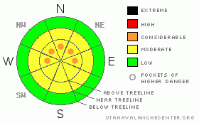
Danger Rose Tutorial
|
Big winds yesterday created fresh windslabs on high elevation slopes near ridgetop. Look for signs of wind deposited snow; fat pillow like features that feel stiff under your machine. The windslab avalanche danger is generally Level 2 (Moderate) with pockets of Level 3 (Considerable) on high elevation slopes that face N, NE & E.
The buried surface hoar hasn't gone away. While the avalanche danger associated with this nasty layer is Level 2 (Moderate), the consequences of triggering an avalanche in the buried surface hoar are severe. This layer exists on high & mid elevation slopes that face NW, N, NE & E. |
|
|
CURRENT CONDITIONS |

|
It's pretty chilly this morning with temps as low as -12 F found at Hayden Fork with winds blowing at moderate speeds out of the north. But, it's worth getting out today if you can; there's 10" - 13" of nice light density Utah cold smoke powder covering the range. Needless to say, riding and turning conditions are currently excellent. |
|
|
RECENT ACTIVITY |

|
Craig and I noted a few surface sluffs yesterday, but, nothing too significant. While not in our area, there was a sledder triggered avalanche in the Snake Creek area of the Central Wasatch. It's always a good idea to see what our neighbors are up to as the adjacent ranges can be quite similar at times. |
|
|
THREAT #1 |

|
| WHERE |
PROBABILITY |
SIZE |
TREND |

|
|
|
|
| |
|
|
Over the next
24 hours.
|
|
|
Most of the wind during the storm was out of the NW, but yesterday we started getting a little weird with more winds out of the NE. Be diligent about looking for signs of wind deposited snow; fat rounded pillow like features that feel stiff under the machine. You're likely to find wind slabs today in places you usually don't.
While *most* of the wind slab activity is rapidly settling out, there are certainly places where you can go and trigger a wind slab avalanche today. I'm thinking about high elevation slopes just below ridge top, places like the Super Bowl or Yamaha Hill. Tweak small test slopes to see how the snow is behaving before formulating plans to tackle the bigger slopes.
If you do trigger a wind slab avalanche today, there is a chance of it stepping down to the buried surface hoar which would result in a deep & unmanageable avalanche. |
|
|
THREAT #2 |

|
| WHERE |
PROBABILITY |
SIZE |
TREND |

|
|
|
|
| |
|
|
Over the next
48 hours.
|
|
|
The buried surface hoar hasn't gone away. It's a nasty little layer because it's honestly pretty hard to predict how it will behave. I don't think anyone really has its number. We just added a bit of weight to its shoulders and we didn't hear of any large avalanches yesterday. But, does that mean that it can handle the additional weight of a rider? Maybe, maybe not. The point is that you can find buried surface hoar on NW, N, NE & E facing aspects throughout the range. Be sure to add this variable into to your mental risk evaluation before jumping on these slopes. If you do trigger an avalanche in the surface hoar one thing is for sure; it will be ugly.
We're particularly interested in what this layer is doing, so, if you see an avalanche out there today, please let us know about it. Thanks! |
|
|
MOUNTAIN WEATHER |

|
While it feels brutally cold this morning, temperatures will rise to the mid teens making for another spectacular day in the mountains. Clouds will be building throughout the day as a small disturbance clips the northern part of the state. We may even see a flury or two this evening, but no significant precip is expected. Thursday brings more sunny skies with temperatures reaching into the upper twenties. Friday looks like more of the same with temps hovering near the freezing mark. It looks like we're setting up for a temperature inversion this weekend with warm temperatures climbing into the upper 30's in the mountains while things remain a little cooler down in town. |
|
|
GENERAL ANNOUNCEMENTS |
The information in this advisory expires 24 hours after the date and time posted, but will be updated by 7:00 AM Saturday, Feb. 12th, 2011.
If you’re getting out and about and trigger an avalanche or see anything interesting please let us know here. Or drop Craig an email : craig@utahavalanchecenter.org or call 801-231-2170
The western Uinta advisory program is going full tilt and forecasts will be issued by 7:00 AM on Wednesday, Saturday, Sunday and all holidays. |
|
|
This information does not apply to developed ski areas or highways where avalanche control is normally done. This advisory is from the U.S.D.A. Forest Service, which is solely responsible for its content. This advisory describes general avalanche conditions and local variations always occur. |
|
This advisory provided by the USDA Forest Service, in partnership with:
The Friends of the Utah Avalanche Center, Utah Division of State Parks and Recreation, Utah Division of Emergency Management, Salt Lake County, Salt Lake Unified Fire Authority and the friends of the La Sal Avalanche Center. See our Sponsors Page for a complete list. |
