AVALANCHE WARNING »
Dangerous avalanche conditions are occuring or are imminent.
Backcountry travel in avalanche terrain is not recommended.
|
 |
Notice: AN AVALANCHE WARNING IS IN EFFECT FOR ALL THE MOUNTAINS IN UTAH. CONTINUED STRONG WINDS AND HEAVY SNOW HAVE CREATED A HIGH AVALANCHE DANGER FOR ALL THE MOUNTAINS OF UTAH. BACKCOUNTRY TRAVELERS SHOULD AVOID ALL AVALANCHE TERRAIN, ESPECIALLY STEEP SLOPES WITH RECENT DEPOSITS OF WIND DRIFTED SNOW. |
|
|
BOTTOM LINE
Danger by aspect and elevation on slopes approaching 35° or steeper.
(click HERE for tomorrow's danger rating)
|
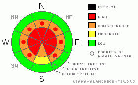
Danger Rose Tutorial
|
At mid and upper elevations the avalanche danger is HIGH (Level 4). Both natural and human triggered avalanches are probable. Avalanches triggered today will be large, dangerous and possibly unsurvivable. A CONSIDERABLE avalanche danger exists on any steep mid elevation slope with recent deposits of wind drifted snow. Out of the wind and at low elevations the avalanche danger is generally LOW. |
|
|
CURRENT CONDITIONS |

|
This week’s series of storms turned our snowpack from zero to hero and in the past 24 hours we received yet another good shot of snow. Overnight totals have been pretty evenly distributed with just over a foot of new at the upper elevations from Daniels, to Trial Lake, to Chalk Creek and around 7” at the trailheads. Winds shifted to the west late last night and are blowing 20-30 mph with gusts in the low 40’s along the high exposed peaks and ridges. Temperatures are in the teens at 10,000’ and in the low 20’s at 8,000’.
|
|
|
RECENT ACTIVITY |

|
One large, bone snapping natural avalanche was reported from upper Weber Canyon occurring on a steep, wind loaded northeast facing slope. The slide was 3’-5’ deep, 250’-300’ wide and failed on weak snow near the ground pulling out the entire season’s snowpack.
In addition, several smaller natural slides were also reported yesterday, most of them 1’-2’ feet deep and running within the new storm snow.
Click here for recent observations.
|
|
|
THREAT #1 |

|
| WHERE |
PROBABILITY |
SIZE |
TREND |

|
|
|
|
| |
|
|
Over the next
24 hours.
|
|
|
Yesterday’s raging south and southwest winds transported an amazing amount of snow onto leeward terrain, not only up high in the wind zone, but well down into mid and low elevation terrain as well. Today those drifts will be covered over with last night’s snow and are hard to detect. While visibility may be limited, you need to look for and avoid any steep slope with recent deposits of wind drifted snow. Avalanches triggered in the newly formed wind drifts can break into weaker layers of snow producing a larger more dangerous avalanche than you might expect.
|
|
|
THREAT #2 |

|
| WHERE |
PROBABILITY |
SIZE |
TREND |

|
|
|
|
| |
|
|
Over the next
24 hours.
|
|
|
On Friday, Grant and I specifically went hunting for weak snow on the southern half of the range to see how it would react to all the added weight of the storm. Ted did the same on the North Slope. (Click here for a brief snowpack tutorial). Our suspicions were confirmed with big red flag warning signs like shooting cracks and booming collapses. As a matter of fact, Grant and I were able to collapse a low angle, 30 degree slope from quite a distance, initiating cracks up to 200’ away. The immediate culprit is the weak near surface facets formed during the December dry spell and our snowpit stability tests reveal this persistent buried weak layer as well. These sugary crystals are buried and preserved in the mid portion of our snowpack and life has been good without any additional weight bearing down on top of them. Essentially they’ve been partying for nearly a month with no worries at all. Now it’s hangover time and they’re reeling from the effects of a heavy dose of fresh snow and strong winds. Many steep slopes throughout the range hang in the balance, just waiting for a rider to come along and reawaken this weak layer. These are exactly the type of snowpack conditions that lead to most fatal avalanche accidents in the western Uinta Mountains. There’s no reason to pull on the dogs tail and second guess the snow stability pattern today. We have a dangerous snowpack and avalanches triggered today can break into weak snow near the ground, resulting in a deep and unsurvivable slide.
|
|
|
MOUNTAIN WEATHER |

|
An unstable airmass remains in place for most of the day, producing scattered snow showers, gusty west and northwest ridgetop winds and cool temperatures. We should see an additional 1”-3” of snow today with another 2”-4” overnight. Winds will average 10-20 mph at most locations with gusts in the low 40’s along the high ridges. Highs at 8,000’ reach into the upper 20’s and at 10,000’ near 20 degrees. Overnight lows will be in the single digits. Partly cloudy skies and a flurry or two are expected for Sunday. A small storm moves through the region late Monday into Tuesday.
|
|
|
GENERAL ANNOUNCEMENTS |
The information in this advisory expires 24 hours after the date and time posted, but will be updated by 7:00 AM Sunday January 24th, 2010.
If you’re getting out and about and trigger an avalanche or see anything interesting please drop us an email at craig@utahavalanchecenter.org or call 801-231-2170 |
|
|
This information does not apply to developed ski areas or highways where avalanche control is normally done. This advisory is from the U.S.D.A. Forest Service, which is solely responsible for its content. This advisory describes general avalanche conditions and local variations always occur. |
|
This advisory provided by the USDA Forest Service, in partnership with:
The Friends of the Utah Avalanche Center, Utah Division of State Parks and Recreation, Utah Division of Emergency Management, Salt Lake County, Salt Lake Unified Fire Authority and the friends of the La Sal Avalanche Center. See our Sponsors Page for a complete list. |
