SPECIAL ANNOUNCEMENT |
 |
The BCA Beacon Basin training site located near the Big Drift parking lot is up and running. Big thanks to everyone for pitching in, installing the targets, and for the continued help maintaining this life saving beacon practice facility. |
|
|
BOTTOM LINE
Danger by aspect and elevation on slopes approaching 35° or steeper.
(click HERE for tomorrow's danger rating)
|
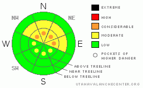
Danger Rose Tutorial
|
While not widespread, at and above treeline you’ll find pockets of Level 3 (CONSIDERABLE) avalanche danger. Deep, dangerous human triggered avalanches breaking to the ground are likely on steep, wind drifted slopes, particularly those facing the north half of the compass.
A Level 2 (MODERATE) avalanche danger exists in steep, mid elevation north facing terrain and human triggered avalanches are possible.
Terrain that faces the south half of the compass and slopes that had no snow prior to the big storm two weeks ago, offer a Level 1 (LOW) avalanche danger. |
|
|
CURRENT CONDITIONS |

|
It’ll be a beautiful day on the Skyline with clear skies and light winds. Currently, temperatures are in the low teens and easterly winds are blowing 5-15 mph. Excellent riding and turning conditions will be found today, particularly on low angle slopes where you won’t punch into the sugary snow near the ground. |
|
|
RECENT ACTIVITY |

|

Natural avalanches breaking to the ground were the norm as a result of the big storm.

Trent looks at the big recent activity on a steep, north facing, upper elevation slope. Huge thanks to Big Pine Sports and Arctic Cat for helping to supply the UAC with this awesome sled for the season.

Zoomed in photo clearly shows huge bone crushing chunks of slab.
Darce, Steve, and their posse were around Electric Lake yesterday and put together this excellent observation with a great viddy explaining what's going on in the hood. Click here to view.
Click here for recent observations from the region. |
|
|
THREAT #1 |

|
| WHERE |
PROBABILITY |
SIZE |
TREND |

|
|
|
|
| |
|
|
Over the next
24 hours.
|
|
|
Traveling to different regions throughout the state this year has been an eye opener to how variable snow depth and strength are throughout the state. One thing is for sure... the Skyline has the weakest snow I’ve seen. This pack is whacked! Click here to see what we're dealing with.
This winters snowpack is so unusual for us and it will create unusual avalanche conditions. Here it is February and we’re still talking about the sugary snow near the ground and we’ve seen widespread avalanche activity breaking to the dirt.
Today’s avalanche danger isn’t going to be as in your face as it was last weekend. Instead, this weekend’s avalanche dragons are more nefarious. They’ll make you feel confident about the snow and your terrain choices because the big storm has settled out, gained strength, and will allow you to ride many slopes without triggering avalanches. The slab will let you get well out onto the slope before it fails and you’re staring down the barrel of a very dangerous slide. Any steep, upper elevation, wind drifted slope facing the north half of the compass should be considered suspect and should be avoided.
It doesn’t mean you can’t ride today, but it does mean you need to choose your terrain carefully and think about the consequences of triggering a slide. If you want to come away from the craps table a winner stick with low angle meadows, south facing terrain, and slopes that had no snow to the big storm. |
|
|
MOUNTAIN WEATHER |

|
It’s a great weekend to be up on the Skyline where you’ll find sunny skies, light winds, and temperatures climbing into the upper 20’s with overnight lows dipping into the low teens. Looks like about the same for the next couple days as high pressure becomes the dominate feature of our weather pattern. |
|
|
GENERAL ANNOUNCEMENTS |
The information in this advisory expires 24 hours after the date and time posted, but will be updated by 7:00 AM Saturday, February 11th. If you’re getting out and about and trigger an avalanche or see anything interesting please drop me an email at craig@utahavalanchecenter.org or call 801-231-2170 Also, now is a great time to schedule one of our free avalanche awareness presentations for your group or club. Email or call me and we’ll get you booked before things get too crazy. |
|
|
This information does not apply to developed ski areas or highways where avalanche control is normally done. This advisory is from the U.S.D.A. Forest Service, which is solely responsible for its content. This advisory describes general avalanche conditions and local variations always occur. |
|
This advisory provided by the USDA Forest Service, in partnership with:
The Friends of the Utah Avalanche Center, Utah Division of State Parks and Recreation, Utah Division of Emergency Management, Salt Lake County, Salt Lake Unified Fire Authority and the friends of the La Sal Avalanche Center. See our Sponsors Page for a complete list. |
