BOTTOM LINE
Danger by aspect and elevation on slopes approaching 35° or steeper.
(click HERE for tomorrow's danger rating)
|

Danger Rose Tutorial
|
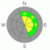
Above treeline there is a MODERATE danger of triggering an avalanche in the new snow on all aspects, especially in areas that have received recent wind loading. There is also a MODERATE danger of triggering a deep slab avalanche on aspects with an east facing component above and in the trees. All other slopes have a LOW avalanche danger. Wet sluffs will be a minor issue on South facing aspects as temps warm up late in the day. |
|
|
CURRENT CONDITIONS |

|
Central Utah received a much needed dump last weekend. We picked up 2' of snow in most locations, up to 3' near 10,000'. The mountains are looking great in their thick coat of white. Total settled snowpack ranges from 3 1/2' near Millers Flat to as much as 6' at the upper elevations. The new snow came in right side up. Warm temperatures delivered wet heavy snow on Saturday. Temperatures gradually cooled off as we made our way through the weekend, and the last snow to fall was high grade Utah powder. Riding conditions are over the hood out there right now with face shots galore. |
|
|
RECENT ACTIVITY |

|
Folks have been getting after it out there, but I haven't heard of any slides pulling out. Amazingly, the snowpack seems to be adjusting to this new load very nicely. On my field day, Brett and I scoured the drainages South of Millers Flat hunting for avalanches, and came home skunked. A bit of the new snow is moving around on wind loaded North through East facing aspects, but these are small, manageable (6 - 12") soft slabs. Once started, they don't move very far either.
If you see or hear of any avalanche activity please let me know about it! |
|
|
THREAT #1 |

|
| WHERE |
PROBABILITY |
SIZE |
TREND |

|
|
|
|
| |
|
|
Over the next
24
hours.
|
|
|
The new snow is bonding well to the old snow interface. At the higher elevations, the snow is still quite light density, limiting travel in the more remote Alpine bowls to skilled riders on high end machines. I haven't seen anyone center punch the big bowls yet. The winds are pushing the snow around a bit up high, and some shallow sensitive wind slabs exist up there. It is possible to trigger an avalanche in the new snow up high, especially in our usual suspect locations; near rocks (cliffs) & on convex rollers, especially in areas that have received recent wind loading, i.e. those on the E side of the compass. |
|
|
THREAT #2 |

|
| WHERE |
PROBABILITY |
SIZE |
TREND |
|
|
|
|
| |
|
|
Over the next
24
hours.
|
|
|
The recent storm snow was a serious test for our deep slabs sitting on the facets at the ground. The verdict is in, and the deep slab is innocent. I could not find any signs of deep natural activity after the storm. This is great news, it means that we are turning the corner on this deep slab weakness. However, it is still possible to trigger the big one in areas of shallow snow pack. (Especially near rock outcroppings). |
|
|
MOUNTAIN WEATHER |

|
Currently on the skyline it's 24 F and winds are light out of the S-SW. A weak disturbance will move through this evening, but no significant snow fall is expected. We're under a ridge of high pressure after tonight & bluebird skies will be the norm through Wednesday. Temperatures will rise to above freezing even at upper elevations which will help to further settle & strengthen our snowpack. Another wet low pressure system comes knocking towards the end of the week which could bring significant snow fall. |
|
|
GENERAL ANNOUNCEMENTS |
If you see or trigger an avalanche it would do the community good to report it. Your observations help to save the lives of others. The forecast area is large, and due to funding cuts I only have one field day to spend on the Skyline. This means that I can't possibly see it all. I need you to help me, help you. Please share your observations and experiences:
Shoot me an email: grant@utahavalanchecenter.org and or call me on my cell: 406-370-1337. Thanks!
Our third annual Avalanche Center fundraising ride is Saturday February 7th. Click here for more details.
Due to budget cuts we are only able to produce an advisory that is updated each Saturday morning.
Keep in mind that conditions change dramatically and that information may not be relevant for later in the week.
Want to schedule an avalanche awareness talk? Contact me for details. |
|
|
This information does not apply to developed ski areas or highways where avalanche control is normally done. This advisory is from the U.S.D.A. Forest Service, which is solely responsible for its content. This advisory describes general avalanche conditions and local variations always occur. |
|
This advisory provided by the USDA Forest Service, in partnership with:
The Friends of the Utah Avalanche Center, Utah Division of State Parks and Recreation, Utah Division of Emergency Management, Salt Lake County, Salt Lake Unified Fire Authority and the friends of the La Sal Avalanche Center. See our Sponsors Page for a complete list. |
