SPECIAL ANNOUNCEMENT |
 |
Highway control work is planned in Big Cottonwood for tomorrow in the Kessler, Argenta and Stairs slide paths, from approximately 8 am to 9 am. Please avoid those avalanche paths Monday morning until control work is completed.
UAC CLOSING AFTER THIS WEEKEND: Today is our last day of issuing advisories for the season as our piggy bank has run dry.
We will continue to accept and publish observations from backcountry users who submit them. You can find them in the Current Conditions off the main menu.
We would like to thank everyone who contributed to your community avalanche center. We are a Forest Service program but over 3/4 of the funding comes from other partners. This includes: all of your donations through Friends of the Utah Avalanche Center, Utah Division of State Parks and Recreation, Utah Public Safety, Salt Lake County, Black Diamond, Backcountry.com, all the ski areas that donated lift tickets, Ski Utah, Unified Fire Authority and the various shops that donate snowmobiles and other equipment such as Polaris/Tri-City Performance, Weller's Recreation/Ski Doo and Arctic Cat/Big Pine Sports, Recco, Wasatch Backcountry Rescue, Back Country Access and ABS. Whew! Forgive me for anyone I have forgotton. As you can see, we have lots of support.
We are still collecting feedback from you with our 10 question survey. Please feel free to let us know you’re thoughts. CLICK FOR SURVEY |
|
|
BOTTOM LINE
Danger by aspect and elevation on slopes approaching 35° or steeper.
(click HERE for tomorrow's danger rating)
|

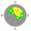
Danger Rose Tutorial
|
The avalanche danger is MODERATE (L2) with Pockets of CONSIDERABLE (L3) for human triggered new snow slides, wind drifts and cornices on steep slopes at the higher elevations. It is also a MODERATE (L2) with Pockets of CONSIDERABLE (L3) for wet loose sluffs and wet slab avalanche on steep low and mid elevation slopes of all aspects, as high as 9,000’ Deep Slab releases are unlikely, but large triggers such as cornice drops or new snow avalanches could release one of these potentially unsurvivable slides. |
|
|
CURRENT CONDITIONS |

|
Rain changed to snow before midnight, and snow totals as 6 am are a foot or more at the higher elevations of the Cottonwoods and Park City ridge line, with 6 to 10 inches at the mid elevations of the Provo and Ogden area mountains. The winds have shifted to the northwest, and are in the 10 to 15 mph range, with the highest peaks averaging 25 mph, gusting to 40. It’s difficult to tell how much rain various places received before it turned to snow, but as much as .4” at some mid elevation stations. 10,000’ foot temperatures are in the mid teens, and still dropping. |
|
|
RECENT ACTIVITY |

|
Yesterday, there were continued concerns of wet activity, especially in the Ogden area mountains and lower Park City terrain. Most avoided the wet snowpack terrain, though natural sluffs did occur, with a great observation of a large slide in a north facing, lower Little Cottonwood gully. |
|
|
THREAT #1 |

|
| WHERE |
PROBABILITY |
SIZE |
TREND |

|
|
|
|
| |
|
|
Over the next
12 hours.
|
|
|
New Snow, Wind Slabs and Cornices headline the avalanche concerns for today. While the new snow is generally “right side up” – becoming dryer and lighter as the storm progressed, - it will be sensitive on steep slopes, especially early in the day or during any periods of intense snowfall. Also, the winds are forecast to pick up later today, and the fresh wind drifts will become increasingly sensitive as they build up in depth and increase in distribution. Out of the wind affected terrain, the new snow will be stabilizing as the day goes on.
The added weight on top of the already large, sagging cornices will make them even more sensitive. Stay well back from the corniced edges when traveling along ridgelines. A big cornice drop is likely to trigger some sort of slide on the slope below – a new snow soft slab or even a deep slab avalanche. |
|
|
THREAT #2 |

|
| WHERE |
PROBABILITY |
SIZE |
TREND |

|
|
|
|
| |
|
|
Over the next
24 hours.
|
|
|
At the mid and low elevations, it may look like powder, but it’s just a thin veneer of dry snow covering and insulating a rain soaked, warm and soggy snow pack. Wet snow issues will be on all aspects at the low and mid elevations, as high as 9,000’ in some locations. Wet loose sluffs will be easy to trigger on steep slopes of all aspects at mid and lower elevations, and definitely keep wet slab avalanches on your radar throughout the day. A sluff may step down, triggering a slab or just gouging and entraining snow, piling up deep, cement like debris. Avoid being below steep, snow covered roofs that may release. |
|
|
THREAT #3 |

|
| WHERE |
PROBABILITY |
SIZE |
TREND |
|
|
|
|
| |
|
|
Over the next
24 hours.
|
|
|
Another rapid loading event means another increased chance for a deep slab avalanche to release somewhere in the backcountry. It would most likely be on an upper elevation, north or northeasterly facing slope involving a steep break over or rocky, unsupported slope. Glide cracks are widening, and may release at any time. |
|
|
MOUNTAIN WEATHER |

|
Several more hours of moderate to heavy snowfall could occur into mid morning, before the snow becomes more showery and convective for the rest of the day. An additional 4 to 7” is possible. Temperatures won’t warm much today – remaining in the low twenties at 8,000’ and in the teens at 10,000’. The northwesterly wind speeds will increase into the afternoon, with averages of 15 to 25 mph and gusts to 40 mph common. The highest peaks could average 30 mph with gusts to 50.
A ridge will build into the Great Basin on Monday, with 10,000’ temperatures warming to near 30 by Tuesday. A weak storm Tuesday night into Wednesday will be followed by a colder, unsettled weather late in the week through the weekend. |
|
|
GENERAL ANNOUNCEMENTS |
GENERAL ANNOUNCEMENTS
If you trigger an avalanche in the backcountry - especially if you are adjacent to a ski area – please call the following teams to alert them to the slide and whether anyone is missing or not. Rescue teams can be exposed to significant hazard when responding to avalanches, and do not want to do so when unneeded. Thanks.
Salt Lake – Alta Central (801-742-2033)
Ogden – Snowbasin Patrol Dispatch (801-620-1017)
Provo – Sundance Patrol Dispatch (801-223-4150)
Discount Lift tickets: Ski Utah, Backcountry.com, Alta, Deer Valley, Park City, The Canyons, Wolf Mountain, Snowbasin, Beaver Mountain, Brighton, Sundance, and Solitude have donated a limited number of tickets for sale.
Wasatch Powderbird Guides flight plan.
Dawn Patrol Forecast Hotline, updated by 05:30: 888-999-4019 option 8.
Daily observations are frequently posted by 10 pm each evening.
Subscribe to the daily avalanche advisory e-mail click HERE.
UDOT canyon closures UDOT at (801) 975-4838
You have the opportunity to participate in the creation of our own community avalanche advisory by submitting avalanche and snow observations. You can also call us at 801-524-5304 or 800-662-4140, or email by clicking HERE
Donate to your favorite non-profit – The Friends of the Utah Avalanche Center. The UAC depends on contributions from users like you to support our work.
The information in this advisory is from the U.S. Forest Service, which is solely responsible for its content. This advisory describes general avalanche conditions and local variations always occur.
We will update this forecast tomorrow morning. Thanks for calling. |
|
|
This information does not apply to developed ski areas or highways where avalanche control is normally done. This advisory is from the U.S.D.A. Forest Service, which is solely responsible for its content. This advisory describes general avalanche conditions and local variations always occur. |
|
This advisory provided by the USDA Forest Service, in partnership with:
The Friends of the Utah Avalanche Center, Utah Division of State Parks and Recreation, Utah Division of Emergency Management, Salt Lake County, Salt Lake Unified Fire Authority and the friends of the La Sal Avalanche Center. See our Sponsors Page for a complete list. |
