BOTTOM LINE
Danger by aspect and elevation on slopes approaching 35° or steeper.
(click HERE for tomorrow's danger rating)
|
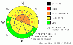
Danger Rose Tutorial
|
The Bottom Line for today will be an increasing avalanche danger from Moderate to Considerable as a winter storm affects southeast Utah.
Although it appears the lower persistent weak layer is starting to heal at and below treeline, new snow instabilities and wind slabs will be our biggest concern as snow accumulates and transports in the mountain ranges. |
|
|
CURRENT CONDITIONS |

|
Another storm system is aligning to bring up to a foot of new snow to the mountains of southeast, Utah. Snow coverage and conditions are really starting to open up the mountains, yet everyone is staying out of large avalanche paths and skiing relatively conservatively, even though folks are able to explore new terrain. This has been accomplished by good route finding techniques (both uphill and downhill) and keeping our human factors under control. By staying in control of the terrain, we have stayed safe. Let's keep it that way.
Today is the 20th anniversary of the Talking Mountain Cirque accident that claimed four community member's lives in the La Sal Mountains. That accident occurred with a weak, shallow snow pack where numerous human factors found the party in a place that they should not have been for the conditions at hand. Let this date act to remind us as a "lessons learned".
|
|
|
RECENT ACTIVITY |

|
The deceptively benign and limited avalanche activity from last week storm and wind event does not give an accurate picture of the potential in certain areas. There were slab avalanches on the west face of Tomasaki, the north face of Mellenthin and numerous sluffs on all aspects.
On Saturday, our group did trigger a small, 30' wide avalanche below tree line on a west aspect on our way out of Gold Basin. There are unstable conditions out there and the new snow will only increase the stress of our shallow pack. |
|
|
THREAT #1 |

|
| WHERE |
PROBABILITY |
SIZE |
TREND |

|
|
|
|
| |
|
|
Over the next
48 hours.
|
|
|
There are two interfaces to track in the mountains that are found on most aspects and elevations. First, everywhere I poke my head into the snow, over half of the snow pack is weak faceted snow grains...a structure that should not be taken lightly. Warm temperatures have allowed the interface to gain strength and lose energy, yet under the proper slope characteristics, this layer WILL fail.
Secondly, a "solar flare" crust has been found at all aspects and elevations just below the new snow from the past week. This crust is developing weak faceted grains above the layer, and sudden planar shears have been repeated during shovel burp tests throughout the La SalMountain range. This crust interface, combined with new snow loading may be the culprit the next avalanche cycle. |
|
|
THREAT #2 |

|
| WHERE |
PROBABILITY |
SIZE |
TREND |

|
|
|
|
| |
|
|
Over the next
48 hours.
|
|
|
More snow and wind will increase the formation of wind slabs on leeward sides of slopes and ridges. Wind slabs are especially tender during or just after their formation. |
|
|
MOUNTAIN WEATHER |

|
@ 10,000' in the La Sal Mountains, Utah
Today: Snow showers. Some thunder is also possible. High near 28. Southwest wind around 15 mph. Chance of precipitation is 100%. Total daytime snow accumulation of 5 to 9 inches possible.
Tonight: Snow, mainly before 11pm. Low around 16. West wind between 10 and 15 mph. Chance of precipitation is 90%. New snow accumulation of 2 to 4 inches possible.
Monday: Snow likely, mainly after 11am. Cloudy, with a high near 28. West southwest wind between 10 and 15 mph. Chance of precipitation is 60%. New snow accumulation of 1 to 2 inches possible.
Monday Night: Snow likely. Cloudy, with a low around 16. Breezy, with a south wind between 10 and 20 mph. Chance of precipitation is 70%. New snow accumulation of 1 to 3 inches possible.
Tuesday: Snow. High near 29. Breezy, with a south wind around 20 mph. Chance of precipitation is 80%.
Tuesday Night: Snow likely. Cloudy, with a low around 15. Chance of precipitation is 70%. |
|
|
This information does not apply to developed ski areas or highways where avalanche control is normally done. This advisory is from the U.S.D.A. Forest Service, which is solely responsible for its content. This advisory describes general avalanche conditions and local variations always occur. |
|
This advisory provided by the USDA Forest Service, in partnership with:
The Friends of the Utah Avalanche Center, Utah Division of State Parks and Recreation, Utah Division of Emergency Management, Salt Lake County, Salt Lake Unified Fire Authority and the friends of the La Sal Avalanche Center. See our Sponsors Page for a complete list. |
