BOTTOM LINE
Danger by aspect and elevation on slopes approaching 35° or steeper.
(click HERE for tomorrow's danger rating)
|
Danger Rose Tutorial
|
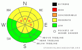
We need more snow. We have a thin snowpack with rotten and unsupportable conditions topped off by a mix of wind and sun crusts. Expect to find a MODERATE avalanche danger in SE Utah on most slopes. Keeping POCKETS of CONSIDERABLE danger in the forecast for upper elevation alpine bowls in the La Sals on N thru NE thru NW facing slopes.
Click here to see the newly revised North American Avalanche Danger Scale. |
|
|
CURRENT CONDITIONS |

|
Good skiing and riding conditions are getting harder and harder to find in the mountains of SE Utah. After a week of high pressure, Strong temperature gradients have weakened the snow on the ground leaving a combination of punchy snow and wind crust over a thin ground cover. Sunny side slopes have sun crusts on them and very little snow. This is making for some challenging and unforgiving conditions. On our tour to Gold Basin on Saturday, we found a wind swept boneyard in Tele Heaven with the best skiing found in avalanche debris from extensive slides off Tukno Mountain. The good news is that we have more snow on the way so read on for more on the weather. We have about 25 inches of snow at the Gold Basin study plot and there are 15 inches at the SNOTEL site above the Geyser Pass Trailhead. These totals put us at about 110 percent of normal snow on the ground for this time of year although It feels like less than that.
Roads to the La Sal Mountain Trailheads (east and west sides) have been cleared by the San Juan County Road Crews. Thanks Guys. The road is getting pretty slick.
LUNA volunteers groomed up and over Geyser Pass Friday. It's a bit rough as this was the first foray to the upper Nordic Trails and it will take a a couple of missions to really smooth it out. The upper Nordic loops were groomed though as was the lower Meadow loop. Enjoy. |
|
|
RECENT ACTIVITY |

|
Check out more info on avalanche classification here.
No recent activity, cracking and collapsing still being noted in the snowpack. |
|
|
THREAT #1 |

|
| WHERE |
PROBABILITY |
SIZE |
TREND |

|
|
|
|
| |
|
|
Over the next
48 hours.
|
|
|
Click here to see the newly revised North American Avalanche Danger Scale.
The Avalanche Danger has lessened in SE Utah with a week of high pressure and lighter winds. We're keeping pockets of CONSIDERABLE Avalanche Danger rating intact for upper elevation slopes above about 11,500 feet in the La Sal Mountains as these areas are more wind loaded. Expect to find a MODERATE Avalanche Danger elsewhere in the mountains of SE Utah. Remember, MODERATE does not mean NO avalanche danger. There is still a lot of collapsing and cracking going on. The snowpack in SE Utah is very weak, which is common this early in the winter. As always, travel in the backcountry with caution.
Our weak snowpack is likely to become an avalanche producer if and when we receive another good snow load. |
|
|
MOUNTAIN WEATHER |

|
National Weather Service Forecast for 10,000 Ft. :
Today: Partly sunny, with a high near 31. South wind around 5 mph, with gusts as high as 20 mph. Tonight: A 30 percent chance of snow, mainly after 11pm. Mostly cloudy, with a low around 19. South southeast wind around 5 mph, with gusts as high as 20 mph. Tuesday: Snow. High near 20. South wind between 10 and 15 mph, with gusts as high as 30 mph. Chance of precipitation is 80%. New snow accumulation of 5 to 9 inches possible. Tuesday Night: Snow likely. Cloudy, with a low around 11. South southeast wind between 10 and 15 mph, with gusts as high as 25 mph. Chance of precipitation is 70%. New snow accumulation of 3 to 5 inches possible. Wednesday: Snow likely. Cloudy, with a high near 21. North northeast wind between 5 and 10 mph. Chance of precipitation is 60%. Wednesday Night: Mostly cloudy, with a low around 10. Thursday: A 20 percent chance of snow. Partly cloudy, with a high near 22. Thursday Night: Mostly cloudy, with a low around 8. Christmas Day: Mostly sunny, with a high near 22. Friday Night: Partly cloudy, with a low around 8. |
|
|
GENERAL ANNOUNCEMENTS |
As the season gets underway, we would like to thank the hard working volunteers at the Friends of the La Sal Avalanche Center. Without thier help the center would not meet it's funding or staffing requirements. Thanks all! If you would like more infomation about donating to the Friends or simply helping out, click here.
Local Avalanche Education:
Basic Avalanche Awareness Class - Grand County Library, January 12th - 5:30 - 8:00 PM.
LSAC Level One Avalanche Class - 3 days, January 29 - 31 - Call 435-636-3363 to reserve a spot or get more info.
This advisory will expire in 48 hours! |
|
|
This information does not apply to developed ski areas or highways where avalanche control is normally done. This advisory is from the U.S.D.A. Forest Service, which is solely responsible for its content. This advisory describes general avalanche conditions and local variations always occur. |
|
This advisory provided by the USDA Forest Service, in partnership with:
The Friends of the Utah Avalanche Center, Utah Division of State Parks and Recreation, Utah Division of Emergency Management, Salt Lake County, Salt Lake Unified Fire Authority and the friends of the La Sal Avalanche Center. See our Sponsors Page for a complete list. |
