BOTTOM LINE
Danger by aspect and elevation on slopes approaching 35° or steeper.
(click HERE for tomorrow's danger rating)
|
Danger Rose Tutorial
|
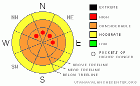
CONSIDERABLE Hazard of Avalanches in the Mountains of SE Utah. Deep slab instabilities linger throughout the west including the mountains of SE UTAH.
South facing slopes now crusted over but good settled powder can still be found in many areas for skiing and riding. As always for this time of year in the La Sal and Abajo Mountains you can expect thin snow coverage and lot's of ground hazard so be careful out there. Keep the slopes angles down and as always, make conservative, informed decisions in your mountain travel |
|
|
CURRENT CONDITIONS |

|
Folks are reporting from the stashes of the La Sals and the skiing and riding conditions are still supportable and good. I hope we get some more snow soon so the pack doesn't loose it's strength from the bottom and become "trap door". Expect early season conditions and plenty of ground hazards. We have about 40 inches of snow on the ground at our Gold Basin Study plot and we're at 135% of normal SWE in the our snowpack.
The Road to the Geyser pass trailhead is buffed. It's in great shape though as always, a minimum of chains carried in your 2wd vehicle are recommended in case it gets slick.Thanks alot San Juan County. It looks great.
Grooming Conditions: LUNA up today to continue efforts on the Main Geyser Pass Road, which needed the most attention. Full track is now groomed including: Lower Meadows, Gold Basin, Geyser Pass Road and Upper Geyser Pass loops. Get it before it snows! |
|
|
RECENT ACTIVITY |

|
Several avalanches were observed last week before the last 14 inches of snow. More were observed today on our tour to the Laurel Ridge Weather Station. These include:
Upper Horse Creek - Soft Slab? Natural, 500' wide x 2-3 feet deep x 1000' vertical. Check out this photo sent in Sunday. www.avalanche.org/~lsafc/aviphotos/LaSalPhotos08-09/12-28-08,Upper Horse Creek, Condie.jpg
Dorry Canyon - SS-NN-R2D2, 2' deep x 200' wide
Snaggletooth Face - Several class 2 avi's in a series of 4-500' couloirs.
Tukno NE Face - SS-NN-R3D2.5 - Large avalanche that ran sometime during Thursday's snow. Impressive.
Talking Mountain Cirque (including lower El Pinche Couloir) SS-NN-R4-D2.5. About 1000' feet wide below the cliffs. Very Widespread.
Laurel Cirque - SS-NN-R4D2. Very Wide but not too deep.
Mt Mellenthin - North face - SS-NN-R3D2.5 - Pretty big one. 2' x 500'
Nothing reported over the last few days, but in Telluride the Ski Patrol is still getting large deep slab avalanches to pull out with control work. |
|
|
THREAT #1 |

|
| WHERE |
PROBABILITY |
SIZE |
TREND |

|
|
|
|
| |
|
|
Over the next
48 hours.
|
|
|
Link to the U.S. Avalanche danger scale here: utahavalanchecenter.org/education/dangerscale
We're Keeping the Avalanche Danger rating at CONSIDERABLE in the mountains of SE Utah for this forecast period. We've left pockets of high hazard on upper elevation Shady side slopes to indicate just how severe triggering a slide in one of these areas would be. It would be BAD. While we are in a declining period of avalanche danger. Deep slab avalanches are still being released by explosives at ski areas close to SE Utah. This indicates that there is still a real possibility of human triggered avalanches. These deep, sometimes hard slabs may allow you to get way out onto the slope before releasing and may not succumb to normal ski cuts and skier pressure until someone tickles it at just the right trigger point. Do yourself a favor and don't mess with these things. We KNOW we have the snowpack to produce deep, persistent slab avalanches. We also KNOW that they are still happening across the west. Don't let the allure of the powder or a steep ride overpower what you already KNOW is a big risk. While this may seem obvious, it's amazing how these risks get overlooked.
Major Surface Hoar development in the La Sals should be watched as we go into next storm cycle.
Check out this powerful interview from one of the survivors of last Saturday's accident involving 8 snowmobilers in B.C. www.theglobeandmail.com/servlet/story/RTGAM.20081231.wvavalnche1231/VideoStory/National/home |
|
|
MOUNTAIN WEATHER |

|
La Sal Mountain Weather for 10,000 ft: Chance of snow this weekend...
Late Afternoon:
A 20 percent chance of snow. Mostly cloudy, with a high near 38. South wind around 10 mph.
Tonight:
Snow likely, mainly after 11pm. Mostly cloudy, with a low around 28. South southeast wind between 10 and 15 mph. Chance of precipitation is 60%. New snow accumulation of less than one inch possible.
Saturday:
Snow. High near 29. Southwest wind 10 to 15 mph becoming north northwest. Chance of precipitation is 90%. New snow accumulation of 2 to 4 inches possible.
Saturday Night:
A 40 percent chance of snow, mainly before 11pm. Mostly cloudy, with a low around 5. West wind between 5 and 10 mph becoming calm. Winds could gust as high as 20 mph.
Sunday:
A 20 percent chance of snow before 11am. Mostly cloudy, with a high near 20. North northwest wind around 5 mph.
Sunday Night:
Mostly cloudy, with a low around 2.
Monday:
Partly sunny, with a high near 23. |
|
|
GENERAL ANNOUNCEMENTS |
Our yearly AIARE level I avalanche course will be held this year from Friday, January 30th - Sunday February 1st. Proceeds from this class go directly to the Friends of La Sal Avalanche Center and help pay for the forecasting and education services provided by the Center. Please call Dave or Max 435-636-3363 to sign up for the class or get more information.
We will also be teaching some Avalanche Awareness seminars this winter. The first is scheduled for Monday, January 12th at 6:00 PM at the Grand County Library. These FREE seminars run about 2 hours and cover avalanche phenomena, basic travel techniques and self-rescue equipment overviews. They are a good opportunity to learn about the hazards of backcountry winter travel. Suitable for skiers, hikers, snow machiners, hunters and snowboarders. |
|
|
This information does not apply to developed ski areas or highways where avalanche control is normally done. This advisory is from the U.S.D.A. Forest Service, which is solely responsible for its content. This advisory describes general avalanche conditions and local variations always occur. |
|
This advisory provided by the USDA Forest Service, in partnership with:
The Friends of the Utah Avalanche Center, Utah Division of State Parks and Recreation, Utah Division of Emergency Management, Salt Lake County, Salt Lake Unified Fire Authority and the friends of the La Sal Avalanche Center. See our Sponsors Page for a complete list. |
