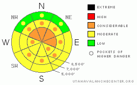
BOTTOM LINE
Danger by aspect and elevation on slopes approaching 35° or steeper.
(click HERE for tomorrow's danger rating)
|
Danger Rose Tutorial
|
There is a Level 3 or Considerable danger on some slopes in the backcountry, and dangerous avalanche conditions exist, mainly in drifted upper elevation terrain... You'd probably trigger stiff wind slab avalanches 1 to 3 feet deep and/or large cornice falls if you travel on steep drifted slopes or venture too close to unstable cornice lips today. You'll find heightened avalanche conditions and a Level 2 or Moderate danger on many other slopes. Dangerous and destructive persistent slab and deep slab avalanches are possible in shady terrain, especially on slopes with poor snow structure and those overrun by wind slab or cornice fall avalanches. But, these dragons will hopefully remain difficult to trigger otherwise. Solar warming will cause a rapid increase in the danger of loose wet and soft new snow slab avalanches on slopes with initially warmed and moistened surface snow...Careful snowpack evaluation, cautious route finding, and conservative decision making are essential in avalanche terrain today. |
|
|
CURRENT CONDITIONS |

|
A couple feet of new snow fell at upper elevations in the mountains around Logan and strong south and then west winds built much deeper drifts in places... Not many people made it out into the backcountry yesterday and parking was made difficult by deep drifted snow at the trailheads. So, you'll find plenty of deep, untracked snow to play in today. Tony Grove Snotel at 8400' reports 2.2" of water from the windy Monday/Tuesday storm. It's 17 degrees this morning and there is 132 inches of total snow with 144% of average water content for the date. The Hwy 89 UDOT Logan Summit weather station reported westerly winds yesterday sustained in the mid-thirties and gusting to 45 mph for several consecutive hours. Strong westerly winds diminished significantly in the Central Bear River Range overnight... |
|
|
RECENT ACTIVITY |

|
Locally, a local rider reported seeing a large fresh natural deep slab avalanche off Millville Peak in Providence Canyon yesterday. Evidence of the fresh avalanche was seen from a bit of distance and across the canyon, but was estimated at around 5 feet deep and 200 feet wide. It was destructive and piled deeply into the ravine below the face..... I found very sensitive conditions and easily triggered a couple fairly large cornice falls off the south ridge of Beaver Mountain yesterday afternoon.
.See our avalanche list HERE
|
|
|
THREAT #1 |

|
| WHERE |
PROBABILITY |
SIZE |
TREND |

|
|
|
|
| |
|
|
Over the next
24 hours.
|
|
|
Avoid fresh wind slabs on steep slopes in lee terrain and deceleration zones or deposition areas... Substantial accumulations and sustained strong south and then west winds created dangerous avalanche conditions in drifted terrain... Although the fresh wind slabs are rapidly becoming stiffer, stubborn, and more stable on most slopes, triggered wind slab avalanches 1 to 3 feet deep are still probable on some steep drifted slopes, especially in upper elevation terrain... Continue to avoid and stay out from under the huge overhanging cornices on the major ridge lines, which often break further back than expected and could trigger dangerous avalanches on steep slopes below. |
|
|
THREAT #2 |

|
| WHERE |
PROBABILITY |
SIZE |
TREND |

|
|
|
|
| |
|
|
Over the next
24 hours.
|
|
|
Dangerous deep slab and shallower persistent slab avalanches involving old snow are possible, and most likely on slopes facing the northern quadrant of the compass. The significant load of new snow from Monday and Tuesday is apparently enough to reactivate deeply buried, mid-winter weak layers in some areas... Deep slab avalanches will probably need a fairly large trigger like overrunning cornice falls or wind slab avalanches, but if triggered they'll certainly pack a destructive and potentially deadly punch... Persistent slabs failing on small-grained sugary or faceted snow and including around a foot of older snow are also possible in some areas... |
|
|
THREAT #3 |

|
| WHERE |
PROBABILITY |
SIZE |
TREND |
|
|
|
|
| |
|
|
Over the next
10 hours.
|
|
|
The danger of wet or moist loose avalanches involving the fresh snow will rapidly rise on sunny slopes as today's temperatures warm up in the middle of the day. Sluffs could entrain significant fresh snow and become dangerous to anyone below or to you on steep slopes around terrain traps like trees or gullies.... Rapid solar warming may also help create sensitive soft slabs, and the initially moistened fresh snow could well become active quickly.... |
|
|
MOUNTAIN WEATHER |

|
We'll get a break from the spring storms today, and we'll see sunny and fairly mild conditions in the mountains today, with temperatures in the mid twenties and a gradually increasing southwest wind... Clouds will return overnight and winds will pick up again ahead of the next shot of snowfall scheduled for tomorrow... We could pick 4 to 6 inches in the high country... Looks like the moist weather pattern will continue through the weekend, with a good chance for more accumulating snow Friday and again Sunday... |
|
|
GENERAL ANNOUNCEMENTS |
We are offering a free avalanche awareness talk for riders on Thursday, March 24 at 6:00 at Renegade Sports in Nibley. This will be followed by a ride into avalanche terrain (field session) on Saturday, March 26.....
You can view a photo summary of last year's avalanche activity in the Logan Area HERE
Join the friends of the Utah Avalanche Center in Logan on facebook. Click HERE
I will update this advisory in the mornings on Mondays, Wednesdays, Fridays, and Saturdays, and on other days if backcountry avalanche conditions warrant...
You have the opportunity to participate in the creation of our own community avalanche advisory by submitting avalanche and snow observations. You can also call us at 801-524-5304 or Toby at 435-757-7578, or email by clicking HERE
Donate to your favorite non-profit – The Friends of the Utah Avalanche Center. The UAC depends on contributions from users like you to support our work.
This advisory is from the U.S.D.A. Forest Service, which is solely responsible for its content. This advisory describes general avalanche conditions and local variations always occur. |
|
|
This information does not apply to developed ski areas or highways where avalanche control is normally done. This advisory is from the U.S.D.A. Forest Service, which is solely responsible for its content. This advisory describes general avalanche conditions and local variations always occur. |
|
This advisory provided by the USDA Forest Service, in partnership with:
The Friends of the Utah Avalanche Center, Utah Division of State Parks and Recreation, Utah Division of Emergency Management, Salt Lake County, Salt Lake Unified Fire Authority and the friends of the La Sal Avalanche Center. See our Sponsors Page for a complete list. |
