BOTTOM LINE
Danger by aspect and elevation on slopes approaching 35° or steeper.
(click HERE for tomorrow's danger rating)
|
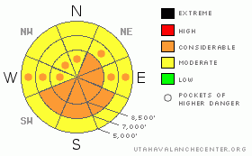
Danger Rose Tutorial
|
There is a CONSIDERABLE danger in the backcountry, and dangerous avalanche conditions exist this morning on some drifted slopes steeper than about 35 degrees, mainly on upper elevation slopes exposed to drifting from a north and northwest wind...Dangerous conditions will also develop on sunny slopes due to rapid solar warming, and triggered and natural wet avalanches will become more likely with midday heating. Rapid solar warming could also cause an increase in slab instability on some slopes. Avoid and stay out from under huge ridge-top cornices...
Use conservative decision making, careful route finding, and good travel habits. Training and experience are essential.... |
|
|
CURRENT CONDITIONS |

|
The Tony Grove Snotel at 8400' reports 5 inches of water equivalent gain since Sunday....We found about 4 feet of fresh, but somewhat stiff, snow above the obvious dirty crust from our last warm spell between 8000' and 8500' in the Tony Grove Area. A stiffer layer, about 6 inches under the surface powder floated us well and with wide boards, trail breaking and turning conditions felt more like a half-a-foot than 4 feet. This was not the really the case on the sled, and the deep, bottomless-feeling snow was a bit of a challenge. I'm sure we weren't the only ones who lost traction in the deep snow, even with the deep powder tracks, and found themselves wallowing in waist-deep powder digging out a stuck machine. The fact that even flats and small hills were a challenge yesterday kept most of us off the steep and suspect slopes...Most avalanche paths in the region have not yet been tested by human weight....
The wind sensor at the Campbell Scientific weather station at 9700' on Logan Peak reports a 5 to10 mph north wind this morning and it's 6 degrees. Reading 10 degrees up at Tony Grove, where, with 102 inches on the total snow-stake, the station sits with 98% of normal water content for the date. |
|
|
RECENT ACTIVITY |

|
Yesterday, Wasatch snow safety crews triggered widespread sizable soft slab avalanches yesterday morning, and a few backcountry skiers intentionally triggered some soft wind slabs as well. By afternoon, most of the instability associated with weak layers within the new snow had settled out...
Locally, an observer noticed evidence of a couple fresh natural avalanches in the Wellsville Range yesterday afternoon... Another noted some filled-in evidence of natural activity on the west side of Logan Peak. We also found evidence of some natural activity from early in the storm. With somewhat limited visibility, we did not observe any fresh natural activity in the Centeral Bear River Range. |
|
|
THREAT #1 |

|
| WHERE |
PROBABILITY |
SIZE |
TREND |

|
|
|
|
| |
|
|
Over the next
24
hours.
|
|
|
Wind slabs built during Wednesday's storm may, in some cases be resting on persistent weak layers and could still be sensitive to human triggers today. Rapid solar warming could cause an increase in slab instability. Most concern centers around layers made up of pooled graupel, and it's also possible that small faceted crystals have formed just above the warm saturated snow that was on the surface a week ago in some areas.
In a worst-case scenario, you could trigger dangerous and broad slab avalanches in the 2 to 4 foot deep range. Smaller yet still dangerous, freshly formed and older wind slabs could be triggered on many drifted slopes steeper than about 35 degrees at all elevations. |
|
|
THREAT #2 |

|
| WHERE |
PROBABILITY |
SIZE |
TREND |

|
|
|
|
| |
|
|
Over the next
10 hours.
|
|
|
Solar warming will drastically affect the fresh snow on sunny slopes today, and wet avalanches are probable on steep slopes where the surface snow becomes saturated. Triggered and some natural loose wet avalanches will become much more likely as slopes are rapidly warmed, starting on east and southeast facing slopes by mid-morning......Rapid solar warming could also cause an increase in slab instability on some slopes....Wind slabs releasing in dry snow in upper elevations could entrain wet snow in descent and become larger and more dangerous avalanches lower down the slope. |
|
|
THREAT #3 |

|
| WHERE |
PROBABILITY |
SIZE |
TREND |

|
|
|
|
| |
|
|
Over the next
24
hours.
|
|
|
Avoid and stay out from under huge ridge-top cornices...These, having been built out anew are still potentially sensitive to your weight, and solar warming today won't help matters..... |
|
|
MOUNTAIN WEATHER |

|
We'll see mostly sunny conditions today, as a short-lived high pressure system controls the weather pattern. It'll be a fair amount warmer and cloudy tomorrow with a south wind, ahead of the next strong and cold Pacific storm, which will bring yet more (potentially significant) snowfall to our area on Sunday. More unsettled and moist spring weather will follow for next week. |
|
|
GENERAL ANNOUNCEMENTS |
Our "Know before You Go" video is available online..... (click HERE to watch it)
Please let us know what you're seeing in the backcountry, especially if you see or trigger an avalanche, by leaving us a message at (435-)755-3638 or 1-800-662-4140. Or, you can always e-mail us at uac@utahavalanchecenter.org. . Your observations are very important for our program.....
This advisory is from the U.S.D.A. Forest Service, which is solely responsible for its content. This advisory describes general avalanche conditions and local variations always occur.
The Utah Avalanche Center depends on contributions from users like you to support our work.
I will update this advisory by around 7:30 Saturday morning. |
|
|
This information does not apply to developed ski areas or highways where avalanche control is normally done. This advisory is from the U.S.D.A. Forest Service, which is solely responsible for its content. This advisory describes general avalanche conditions and local variations always occur. |
|
This advisory provided by the USDA Forest Service, in partnership with:
The Friends of the Utah Avalanche Center, Utah Division of State Parks and Recreation, Utah Division of Emergency Management, Salt Lake County, Salt Lake Unified Fire Authority and the friends of the La Sal Avalanche Center. See our Sponsors Page for a complete list. |
