BOTTOM LINE
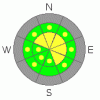
Danger by aspect and elevation on slopes approaching 35° or steeper.
(click HERE for tomorrow's danger rating)
|

Danger Rose Tutorial
|
Overall there is a MODERATE danger in the backcountry, and you could trigger dangerous wet avalanches on steep slopes with saturated snow in many areas. The danger will rise with daytime and solar heating, and air temperatures could get quite warm in sheltered and sunny bowl areas, which reflect solar radiation inward like solar ovens. With this possibility in mind and with a fair amount of uncertainty, I have added a few pockets with a CONSIDERABLE danger to the southern side of the danger rose. Expect similar conditions on Thursday.
Evaluate the snow and terrain carefully and use good travel habits. |
|
|
CURRENT CONDITIONS |

|
The warm weather will continue, with lots of powerful spring sunshine in the mountains today. Clearing will have helped with a surface refreeze overnight, but temperatures only dropped a few degrees and will quickly rise again today. In most areas the snowpack is saturated, and the refreeze is only superficial. |
|
|
RECENT ACTIVITY |

|
We noted some natural wind slab and wet avalanche activity in the Southern Wellsvilles with a rising danger on Monday. (3-16-09 PHOTOS)
Ski areas and road crews in the Wasatch Range also report an increase in danger, with some natural and triggered wet avalanches yesterday on southerly facing slopes as well as northerly......
(3-18-09 Mendon Peak Area PHOTOS) |
|
|
THREAT #1 |

|
| WHERE |
PROBABILITY |
SIZE |
TREND |

|
|
|
|
| |
|
|
Over the next
24
hours.
|
|
|
Last night's refreeze was superficial at best, but clearing skies have released long wave radiation (heat) trapped in the lower atmosphere. I am happy to see the clearing and suspect that it will help reduce the wet avalanche danger we've been seeing recently on northerly facing slopes. The problem is, the sun will be back out with its full seasonal strength, and winds will be light to nil, especially in sheltered, solar-oven-like bowl areas.
Continued warm weather, especially warm nights and poor overnight refreezes, will likely keep wet avalanches on top of the threat list for the next few days........ |
|
|
THREAT #2 |

|
| WHERE |
PROBABILITY |
SIZE |
TREND |
|
|
|
|
| |
|
|
Over the next
24
hours.
|
|
|
Wet or moist slab avalanches are possible on some steep slopes. Small faceted grains have formed just above the dark dusty crust from the beginning of the month. Avalanches stepping down to this weak layer could be about a foot deep and the potential heavy moist slab layer might make them rather unmanageable.
(3-16-09 snow profile) |
|
|
MOUNTAIN WEATHER |

|
Looks like the warm spell will continue for the next few days, with party cloudy skies and light west winds today and tonight... It'll be partly cloudy again tomorrow, and warmer. Rain and snow showers, and a thunder storm or two are possible on Friday. Saturday looks like it will be very warm, windy, and cloudy. |
|
|
GENERAL ANNOUNCEMENTS |
Please show your support for the Logan branch of the Utah Avalanche Center and help us create more helpful forecast products by taking our quick and easy on-line Web survey, (click HERE to partake).
The North American Avalanche Danger Scale is being revised for next winter. Our friends in Canada have created a short survey found at the following link. Please help ensure the new Avalanche Danger Scale is effective by completing a survey. (click HERE)
Our "Know before You Go" video is available online..... (click HERE to watch it)
Please let us know what you're seeing in the backcountry, especially if you see or trigger an avalanche, by leaving us a message at (435-)755-3638 or 1-800-662-4140. Or, you can always e-mail us at uac@utahavalanchecenter.org. . Your observations are very important for our program.....
This advisory is from the U.S.D.A. Forest Service, which is solely responsible for its content. This advisory describes general avalanche conditions and local variations always occur.
The Utah Avalanche Center depends on contributions from users like you to support our work.
I will update this advisory by around 7:30 Friday morning. |
|
|
This information does not apply to developed ski areas or highways where avalanche control is normally done. This advisory is from the U.S.D.A. Forest Service, which is solely responsible for its content. This advisory describes general avalanche conditions and local variations always occur. |
|
This advisory provided by the USDA Forest Service, in partnership with:
The Friends of the Utah Avalanche Center, Utah Division of State Parks and Recreation, Utah Division of Emergency Management, Salt Lake County, Salt Lake Unified Fire Authority and the friends of the La Sal Avalanche Center. See our Sponsors Page for a complete list. |
