Observation: Twin Lakes Pass

Observation Date
1/13/2024
Observer Name
Kelly, Babbit
Region
Salt Lake » Little Cottonwood Canyon » Grizzly Gulch » Twin Lakes Pass
Location Name or Route
Twin Lakes Pass
Weather
Sky
Overcast
Precipitation
Moderate Snowfall
Wind Direction
Southwest
Wind Speed
Light
Weather Comments
Winds blowing from a westerly direction picked up around 9,600' and then slowly decreased as the snowfall rate increased.
Snow Characteristics
New Snow Depth
8"
New Snow Density
Medium
Snow Surface Conditions
Powder
Snow Characteristics Comments
8" of medium-density switching to lower-density snow. Temperatures at the nearby Honeycomb Weather Station were 14°F.
Red Flags
Red Flags
Heavy Snowfall
Wind Loading
Poor Snowpack Structure
Avalanche Problem #1
Problem
Wind Drifted Snow
Trend
Same
Problem #1 Comments
New snow was sitting on top of a hollow wind-board in many places and while we could get some sloughing in the new snow we did not hear or feel any collapses or see cracking below the wind board. There were numerous large cornices on ridgelines, and huge wind rolls in unlikely places below treeline. There were also places where the wind had eroded the new snow away and down to a hard surface. Cornices were not as sensitive as we would have expected and what was surprising was the amount of snow in the trees considering how strong the winds have blown recently.
Photo of cornice east facing Twin Lakes Pass 10,100'. Photo also shows snow on the leeward (east facing) side of the trees
Photo of wind-eroded surface below treeline 9,600'. Photo also shows wind not on the windward (west facing) side of the trees
Avalanche Problem #2
Problem
Persistent Weak Layer
Trend
Increasing Danger
Problem #2 Comments
In higher elevation, thicker snowpack areas there were places with rounding facets on the ground and the weaker snow was above a crust at the new/old snow interface. We observed the remants of an avalanche in Heaven's Gate (East Facing 10,330') that looked to be 100-150' and ran 500' vertical where there was snow from the powder cloud on the trees in the runout zone up to 6' above the snow surface. This is a repeater avalanche that was reported on December 3, 2023. We could see an old crown line and there were 2 avalanches reported in this zone on January 10, 2024.
We were not going onto the bed surface to look at the weak layer as the crown face had only about 4" showing above the newest snow and wind-drifted snow. More weight is on the way and I think that repeater avalanches, places with a thinner snowpack that already slid this season will be the first to avalanche if they haven't already. These will be followed by thinner snowpack areas as we have seen in the avalanche observations over the past few days.
Photo of filled back in crown line (Heaven's Gate)
Snow Profile
Aspect
South
Elevation
10,400'
Slope Angle
30°
Comments
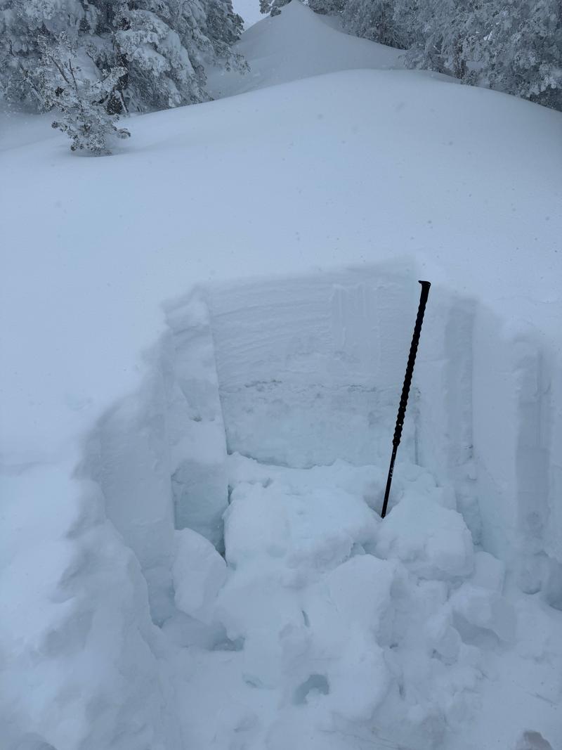
Primary layer of concern was small facets under wind-drifted snow above pencil hard crust. Second layer was dry facets below the pencil hard crust. It will take a lot of weight to break through this crust and in this location I would imagine that the old/new snow interface and density changes would be the first layer to break in the newest snow and the potential for stepping down may exist, but it would be a lot of additional weight to break through this pencil hard crust. The snow structure on this aspect at this elevation in this location
Today we avoided all avalanche terrain and slopes steeper than 30°. We traveled with a high danger mindset. The snowpack has gone through rapid changes this week with more on the way as additional snow and wind are added. We decided that now is not the time to push terrain choices and that is why we stuck with lower angle terrain.
We often refer to Roger Atkins Paper on the Yin, Yang and You from an operational (ski area, highway, guiding service) standpoint. I also find it helpful when making travel decisions in avalanche terrain and being able to discuss what the goal of the tour is with my touring partners. For today our plan was to step back and avoid suspect terrain because of the changing weather conditions.
Today's Observed Danger Rating
High
Tomorrows Estimated Danger Rating
None
Coordinates