


Mark Staples
Director, Forest Service Utah Avalanche Center
The million dollar question:
This time of year, everyone wants to know how much snow we'll get. What are the predictions? My standard response is that it's going to be a huge winter! Why not? We're all eternal optimists, and I was right last winter which went beyond record breaking to nearly historic levels.
So, really, what about this coming winter? There are a few things we can say.
It's an El Nino winter. According to the Climate Prediction Center of the National Weather Service (NWS) - "El Niño is anticipated to continue through the Northern Hemisphere winter (with greater than 95% chance through January - March)"
I've always been bit confused about what El Nino and La Nina really mean other that they have to do with ocean temperatures which can affect large scale weather patterns. Look at the image below and watch the video from NOAA to understand more. Read more details HERE
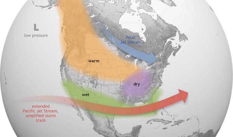
Bottom line - El Nino is supposed to push the jet stream south. Think of the jet stream as a conveyor belt of weather across the US that pulls and pushes warm and cold air over different parts of the US and brings storms and snowfall.
How does it affect Utah? Notice that Utah is mostly in between zones of warmer/drier conditions to the north and wetter conditions to the south. Basically, it's just a coin toss what will happen in Utah in terms of being colder/warmer and wetter/drier than average.
According to Jim Steenburgh, author of "Secrets of the Greatest Snow on Earth" and Professor of Atmospheric Sciences at the University of Utah: "For the central Wasatch, there's very little correlation between El Niño and snowfall. The graph below shows the relationship between 3-month snowfall and an index of El Niño/La Niña strength. Nothing really to bank on here." He explains more in his Blog in a post about the 2015-2016 winter which was an El Nino winter. The graph below shows snowfall at Atla Guard compared with El Nino/La Nina conditions.
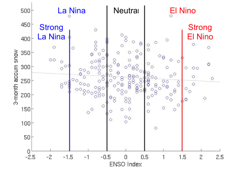
Graph from Jim's Blog site: "Three month (NDJ, DJF, JFM, FMA) accumulated snowfall at Alta–Guard vs. the corresponding ONI (labeled ENSO index).
Courtesy Jeff Massey."
Courtesy Jeff Massey."
But there's more!!!
Recent research at the University of Washington has found a way to predict how much snow we'll get this winter. Seriously?
"The amount of snow already on the ground by the end of December is a good predictor of how much total snow that area will get. This prediction works well in northern states such as Alaska, Oregon and Washington, as well as in parts of Utah, Wyoming and Colorado. Other states, such as California, Nevada, New Mexico and Arizona, were harder to predict."
"There were a few different reasons for why fall snow levels predicted peak season snowpack levels. Some areas, such as Alaska, simply receive most of their snow before January. This means their early season snow is close to their peak season snow. In other places, including Interior Alaska, northeast Utah and southwestern Wyoming, the weather patterns are such that above-average snowfall earlier in the season indicates above-average snowfall is also likely later in the season."
"Cooler air temperatures also helped with predictability. In northern states — such as Alaska, Washington and Oregon — or in places at higher elevation, snow on the ground in the fall was less likely to melt between storms because the air remained cool. That means this snow will stick around and add to the total snowpack."
We see this often in Utah on southerly and low-elevation slopes where it is critical to get early-season snow cover. If snow doesn't cover those slopes by February, the sun is just too strong and melts snow nearly as fast as it accumulates.
There you have it. By the end of December, we can make our prediction. If you're interested in more details about this research, read the published paper HERE or the summary story HERE.
For a detailed analysis of the winter outlook for Utah for winter 2023-2024 watch the great video below from the Salt Lake City Weather Forecasting Office of the National Weather Service.
Leave a comment
Comments