Forecast for the Uintas Area Mountains

Craig Gordon
Issued by Craig Gordon for
Friday, March 22, 2024
It's time to stretch your wings and paddle out into a sea of green avy hazard-
LOW avalanche is found on most slopes throughout the Uinta range and human triggered avalanches are UNLIKELY.
Note to self... I remember hearing Low avy danger doesn't mean No avy danger. And that mantra suggests I still travel with caution and carry rescue gear. I evaluate each slope on an individual basis. And I only expose one person at a time to hazard. Done, done, and done... sounds pretty straight-forward.

Low
Moderate
Considerable
High
Extreme
Learn how to read the forecast here
Special Announcements
Please help support the UAC rebuild our website backend platform to ensure the ongoing security of the website and the data stored on the site by donating to our spring campaign. Save lives by making a donation today!
Weather and Snow
Nowcast- Skies cleared overnight in the wake of yesterday's weak, cool front which delivered a thin coat of white paint... or in technical terms... a couple traces of snow. Temperatures cooled off nicely right around suppertime and currently register in the mid 20's across the board, whilst winds blow 20-30 mph from the west near the high peaks. The corn harvest is going strong and is of course, aspect and cloud cover dependent. Sunnies generally kick off the party around 10:00, and working around the compass towards west facing, should last into early afternoon. On the other side of the compass, you'll find a few swaths of shallow, hot pow on upper elevation shadies.
Forecast- Mostly sunny skies wrap up the end of the work week while high temperatures climb into the 40's. Clouds drift into the Uinta zone and a slight chance of light snow materializes late in the day. Southerly winds ramp up throughout the day, blowing in the 30's and 40's by sunset.
Futurecast- The weekend kicks off with cloudy skies and a robust cold front sliding into the area Saturday afternoon into Saturday evening, delivering a period of heavy snow and strong northwest winds. 6"-10" of storm snow is a good bet for Sunday morning. The active pattern continues with light snow accumulations through Wednesday. Another strong storm is in the queue for Thursday into Friday.
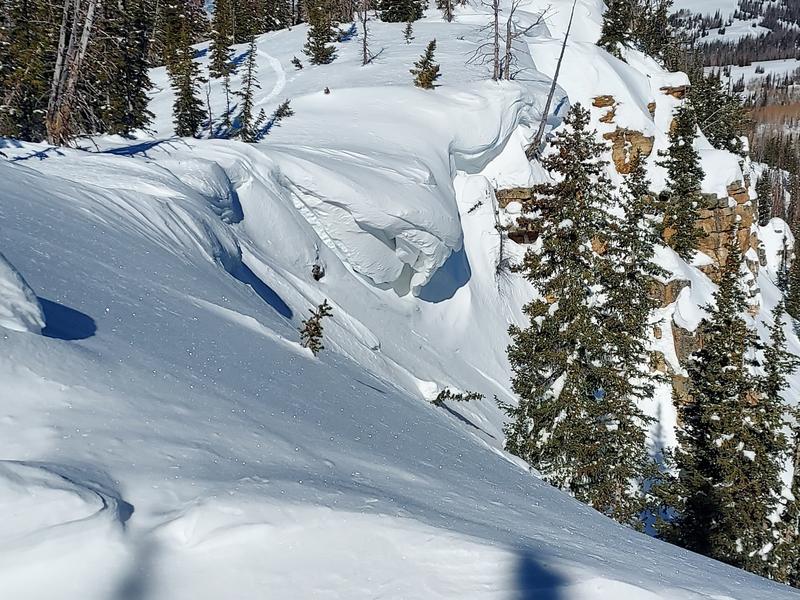
A room with a view.... spectacular sight-seeing and a glimpse of the sleeping maiden.
Recent Avalanches
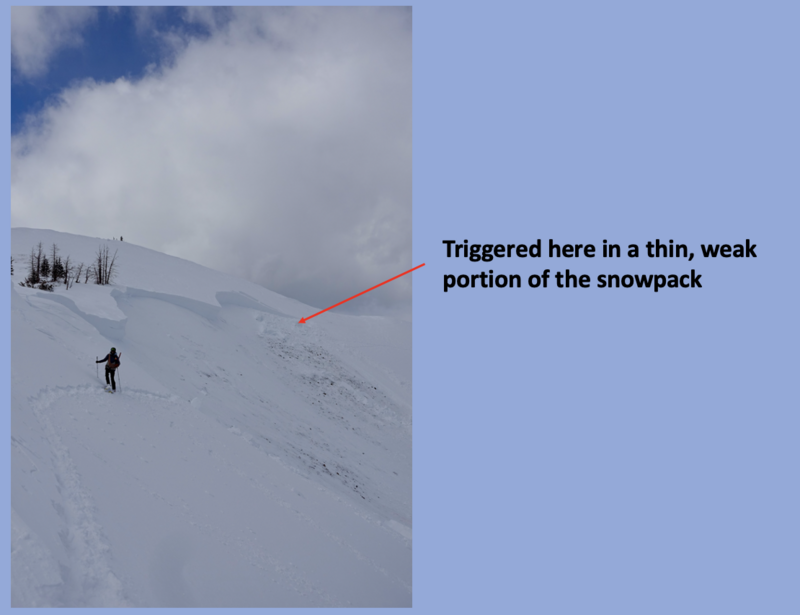
No significant avalanche activity to report.

For all Uinta observations and archived avalanche activity click HERE.
Ad
Avalanche Problem #1
Normal Caution
Type
Location
Likelihood
Size
Description
The snowpack is deep, it's homogeneous, it's happy in its own skin, and it's generally bomb dot com. Yeah... avy danger is straight-forward and there's plenty of room to roam on a go-anywhere base.
A couple things to consider as we stretch our wings-
Boxcar sized cornice loom large overhead and are unpredictably peeling off of ridges. Please give these Titanic sinking pieces of snow a wide margin of error as they would instantly ruin your day if you're clobbered by one.
It's been over three weeks since we observed or recorded an avalanche breaking to old snow. With miles and miles of solid snow, you'd have to get extremely unlucky to trigger a slide that breaks to old, weak layers of snow now buried deep in the snowpack. In other words... if you did trigger a deep, dangerous avalanche then it's probably not time to head to Vegas on a hunch you're gonna do well at the craps table :) The usual, dark alley suspects come to mind... steep, rocky slopes in the wind zone is the kind of terrain we wanna steer clear of.
Additional Information
The Uinta weather station network was upgraded this summer and all that real-time info is found HERE. Simply click on "western Uinta" tab and then "weather stations" tab.

We are always looking for snow and avalanche observations or just general riding conditions. So... if you see something, say something. You can reach me directly at [email protected] or 801-231-2170.
Also, if you're looking for more avy education opportunities for yourself, your crew, or your club please don't hesitate to reach out to me and we'll find a presentation, class, or clinic for ya!
General Announcements

Issued 0330 on Friday, March 22nd this forecast will be updated by 0700 Saturday, March 23rd, 2024.
This forecast is from the U.S.D.A. Forest Service, which is solely responsible for its content. This forecast describes general avalanche conditions and local variations always occur.