Forecast for the Uintas Area Mountains

Craig Gordon
Issued by Craig Gordon for
Tuesday, March 19, 2024
Keep your eyes on the prize if you plan on stepping into steep, committing terrain-
While LOW avalanche is found on most slopes throughout the Uinta range, pockets of MODERATE avalanche danger still exist in steep, rocky terrain above treeline. Human triggered avalanches breaking deeper and wider than you might expect are still possible, especially on steep, wind drifted slopes facing the north half of the compass, and particularly in terrain that has avalanched several times this season.

Low
Moderate
Considerable
High
Extreme
Learn how to read the forecast here
Special Announcements
Please help support the UAC rebuild our website backend platform to ensure the ongoing security of the website and the data stored on the site by donating to our spring campaign. Save lives by making a donation today!
Weather and Snow
Nowcast- High pressure builds overhead, welcoming the first day of Spring, delivering slightly warmer overnight temperatures along with severe clear skies. Currently, temperatures are slightly inverted, registering in the teens at lower elevations where cold air pools and upper 20's closer to the ridges. Winds blew 10-20 mph from the north until the turn of the new day, but backed off, and now barely spin ridgetop anemometers, blowing just 5-10 mph. Riding and turning conditions are aspect dependent... sunnies offer a legit corn harvest that kicks off around 10:00, and working around the compass towards west facing, should last into early afternoon. Meanwhile, the upper elevation shadies offer patches of soft settled snow.
Forecast- Look for mostly sunny skies, light winds, and high temperatures climbing into the mid 40's. Overnight lows dip into the upper 20's.
Futurecast- Rinse and repeat... no major change slated for Wednesday, but clouds drift into the region Thursday, offering a few afternoon and early evening snow showers. Ridging briefly settles in to wrap up the workweek bringing dry, stable conditions. Confidence increases for a strong cold front sliding through the region this weekend.
Recent Avalanches
A few days old, but honorable mention-worthy none-the-less-
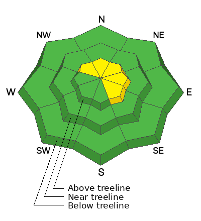
Along the Strawberry Ridge, a snowbiker triggered and was caught in a stout wind drift, breaking 2.5' deep and 300' wide.
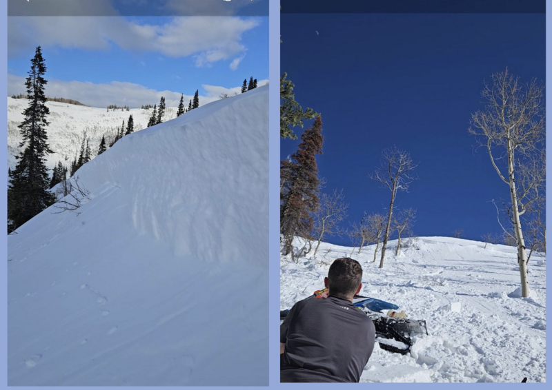
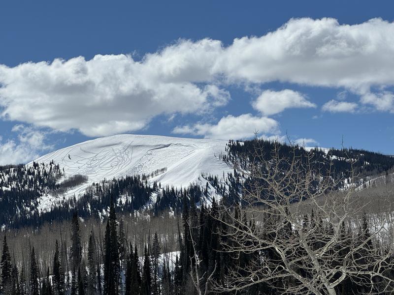
Near Currant Creek Peak, Chad spotted this meaty slab avalanche breaking 4' deep and 150' wide, triggered by a sledder riding nearby.

For all Uinta observations and recent avalanche activity click HERE.
Ad
Avalanche Problem #1
Persistent Weak Layer
Type
Location
Likelihood
Size
Description
Where the snowpack is deep it's homogeneous, it's happy in its own skin, and it's generally bomb dot com. But here's the deal... we don't trigger deep, dangerous avalanches from thick portions of snow, rather it's from thin spots, like around bushes or rocks poking out from the snow, or barely hidden under the snow surface and we can't 'em. In either case, with miles and miles of solid snow and predictable avy conditions, you'd have to get very unlucky to trigger a slide that breaks to old, weak layers of snow now buried deep in the snowpack. The usual suspects come to mind... steep, rocky slopes in the wind zone is the kind of terrain we wanna steer clear of.
Additional Information
The Uinta weather station network was upgraded this summer and all that real-time info is found HERE. Simply click on "western Uinta" tab and then "weather stations" tab.

We are always looking for snow and avalanche observations or just general riding conditions. So... if you see something, say something. You can reach me directly at [email protected] or 801-231-2170.
Also, if you're looking for more avy education opportunities for yourself, your crew, or your club please don't hesitate to reach out to me and we'll find a presentation, class, or clinic for ya!
General Announcements

Issued 0330 on Tuesday, March 19th this forecast will be updated by 0700 Wednesday, March 20th, 2024.
This forecast is from the U.S.D.A. Forest Service, which is solely responsible for its content. This forecast describes general avalanche conditions and local variations always occur.