Forecast for the Uintas Area Mountains

Craig Gordon
Issued by Craig Gordon for
Thursday, February 29, 2024
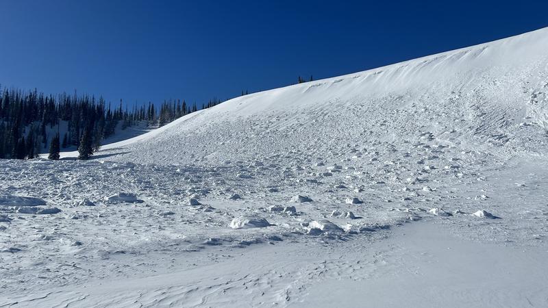
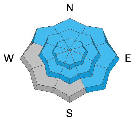
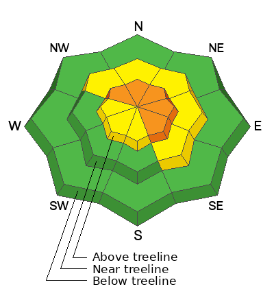
While not widespread, pockets of CONSIDERABLE avalanche danger are found at and above treeline. Human triggered avalanches are LIKELY on steep, shady slopes, especially in the wind-zone where you'll encounter fresh drifts reactive to our additional weight. Becoming more the exception than the rule, we can still trigger a deep, dangerous slide that breaks to the ground in steep, rocky terrain facing the north half of the compass.
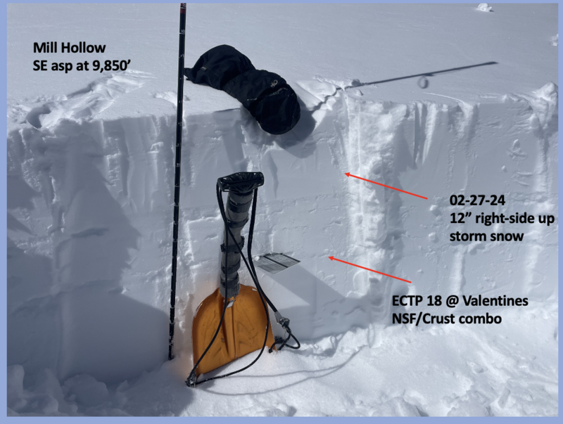
Storm snow, coupled with recent strong wind, created drifts on high elevation sunnies and dot shady slopes near treeline. You'll find MODERATE avalanche danger and human triggered avalanches are POSSIBLE in steep, wind drifted terrain.
Most lower elevation terrain and slopes near treeline facing the south half of the compass offer LOW avalanche danger and human triggered slides are UNLIKELY.

Low
Moderate
Considerable
High
Extreme
Learn how to read the forecast here
Special Announcements
We are seeking a passionate individual to join us as Executive Director of the nonprofit Utah Avalanche Center. Click here for more information.
Weather and Snow
Nowcast- A break in the action brings February to a close with clear skies overhead while the warm before the storm begins kicking in. Temperatures eye the end of the graveyard shift registering in the upper teens, which is about 10 degrees warmer than yesterday at this time. South and southwest winds flirted with a brief bump into the upper 20's late Wednesday, but after a few complaints from nearby mountain ranges, decided to take it down a notch overnight and currently blow in teens near the high peaks. Our fresh coat of white paint took on a little warmth yesterday and sunny slopes will offer a heat crust. But swing over to the north half of the compass, grab a little elevation, and you'll be rewarded cold, shallow pow.
Forecast- High pressure visits the Beehive state for another day and we'll see sunny skies with temperatures warming into the mid 30's. Southerly winds become obnoxious as the day wares on, ramping into the 30's and 40's by late afternoon.
Futurecast- A solid looking, yet rather complex storm sets its sights on the Uinta region for Friday, continuing through much of the weekend. Look for increasing clouds and strong winds to wrap up the workweek, with snow developing by about sunrise. Heavy snow is on tap for Saturday and Sunday with storm totals in the 10"-18" likely by the time the storm winds down Monday.

SNOTEL sites in the Uintas, and much are Utah, report snow water equivalent amounts of 104%-146% of the 30 year median.
Recent Avalanches
Big winds on Tuesday delivered rather well-connected drifting and a fresh, meaty avalanche on Yamaha Hill.
A repeater avalanche path in Weber Canyon, this east facing slope in the alpine delivers several natural avalanches that broke close to the ground in steep, rocky terrain.
For all Uinta observations and recent avalanche activity click HERE.
Ad
Avalanche Problem #1
Persistent Weak Layer
Type
Location
Likelihood
Size
Description
Tuesday's strong winds and dense snow overload steep rocky terrain in Upper Chalk Creek, producing a rather stout slide in terrain that has avalanched several times this season.
The odds of triggering an avalanche breaking to older snow near the ground are markedly different from one slope to the next, so we need to give this some thought. Sure, much of our terrain offers a deep and relatively strong snowpack and triggering a monster slide is unlikely, while other slopes, especially those that have remained thin and weak this season are likely suspects and need to be avoided. Terrain that has avalanched multiple times and slopes that have been stripped by strong winds fit into this category. Avoiding this deep, dangerous avalanche dragon is the ticket, but ya gotta do your homework and identity terrain with shallow snow.
Note to self-
Steep, rocky zones are likely trigger points because they offer a much thinner snowpack and we can effect the weak snow.
Avalanche Problem #2
Wind Drifted Snow
Type
Location
Likelihood
Size
Description
Recent strong winds blew from nearly every direction, whipping up drifts in leeward terrain as well as creating rather large, overhanging cornice features which can break back further than you might expect.
Tuesday's winds were all over the map, drifting snow in unusual locations and lower down-slope than we expect to see. Stomping around yesterday, it felt like most of the drifting issues settled out, were welded in place, or just plain unreactive. However, I'm still steering clear of fat rounded pieces of snow, especially if they sound hollow like a drum.
Avalanche Problem #3
New Snow
Type
Location
Likelihood
Size
Description
The jury is still out on the Valentines Day NSF/Crust combo and I need to investigate a little more before putting this layer to bed. However, I did still find the VD layer reactive in my snow stability tests yesterday.
Tuesday's storm snow is beginning to settle, strengthen, and morph into a cohesive slab. But don't forget.. this fresh snow rests on a thin, weak layer of facets created right around Valentines Day, especially on slopes facing the south half of the compass, and is now buried a couple feet deep. I suspect that time, along with the recent bout of warm temperatures are the great equalizer and the snow is becoming comfortable in its own skin. And while I think you could still trigger an avalanche on this layer, it's becoming more the exception than the rule.
Additional Information
The Uinta weather station network was upgraded this summer and all that real-time info is found HERE. Simply click on "western Uinta" tab and then "weather stations" tab.

We are always looking for snow and avalanche observations or just general riding conditions. So... if you see something, say something. You can reach me directly at [email protected] or 801-231-2170.
Also, if you're looking for more avy education opportunities for yourself, your crew, or your club please don't hesitate to reach out to me and we'll find a presentation, class, or clinic for ya!
General Announcements

Issued at 0330 on Thursday, February 29th this forecast will be updated by 0700 Friday, March 1st, 2024.
This forecast is from the U.S.D.A. Forest Service, which is solely responsible for its content. This forecast describes general avalanche conditions and local variations always occur.