Forecast for the Moab Area Mountains

Eric Trenbeath
Issued by Eric Trenbeath for
Saturday, April 6, 2024
The avalanche danger is generally LOW. Small avalanches remain possible on isolated terrain features or in areas of extreme terrain. Be on the lookout for fresh, shallow deposits of wind drifted snow.
Practice safe travel techniques and carry rescue gear. Ski or ride steep slopes one at a time.
Low
Moderate
Considerable
High
Extreme
Learn how to read the forecast here
Special Announcements
Road Conditions: The lower end of the Geyser Pass road is now mostly dry dirt. Melting snow on the upper end will make for sloppy and muddy conditions later in the day.
Grooming: The trail into Gold Basin was last rolled out on Monday.
Weather and Snow
6:00 a.m. Snow and Weather Data
24 Hour Snow 0" 72 Hour Snow 0" Season Total Snow 190" Depth at Gold Basin 62"
Winds on Pre-Laurel Peak: WSW 10-15 Temp 16° F Percent of Normal: 125%

Weather
Winds backed off and shifted to more westerly around midnight last night. They spent most of yesterday blowing out of the south at speeds of 30 - 40 mph with only one recorded gust into the 50's. We've seen worse, the problem was that it was blowing just as hard down in the desert. Unfortunately, it looks like westerly winds will be on the increase again today as the center of the low pressure system moves into Colorado. Look for partly sunny skies and cold temperatures with highs at 10,000' barely exceeding the low 20's. Tomorrow looks like a decent day to go up and survey the damage with mostly sunny skies, light to moderate westerly winds, and high temps creeping into the upper 20's. Dry and warmer conditions develop through the week.
General Conditions
Only trace amounts of snow fell out of this storm and it's fairly safe to say that conditions have taken a hit after the onslaught of wind and dust. Expect to find a variety of wind and sun crusts out there along with some dirty snow and maybe some isolated wind slabs. I pretty much hid from the wind yesterday, and did a windshield tour around the east side of the range to check out snow cover on some of the bigger southerly facing lines in anticipation of a potential corn cycle next week. Snow cover was still pretty good in spite of the snow stripping winds, the problem will be in how coated they are with dust. I'll get back to you on that once I get a good look around.
Of note: Dave and I continue to find shallow areas with poor snowpack structure, or in other words, weak faceted snow under old wind slabs. More the exception than the rule, you can nevertheless find this structure in repeat running slide paths, along wind swept ridges, and along wind scoured slope margins near rocky outcrops. If you are getting into higher, more extreme terrain, it's worth poking around and looking for this weak structure, and maybe reconsidering your line if you find it.
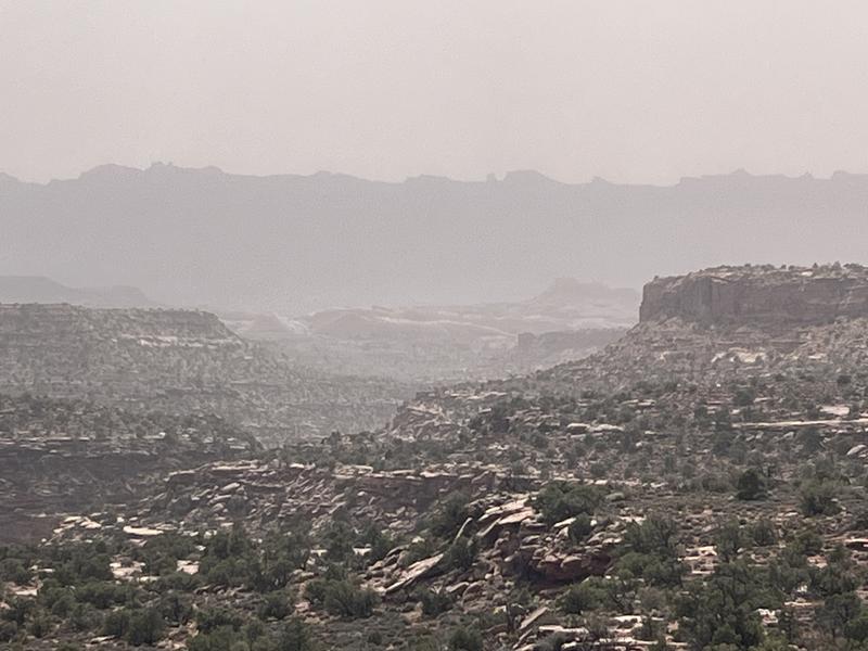
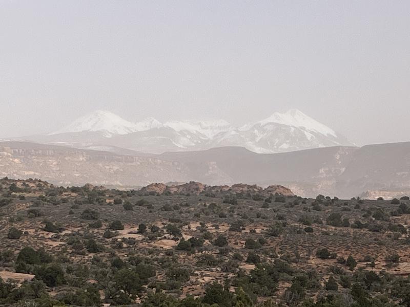
Desert dust:
Mountains obscured by a dusty haze:
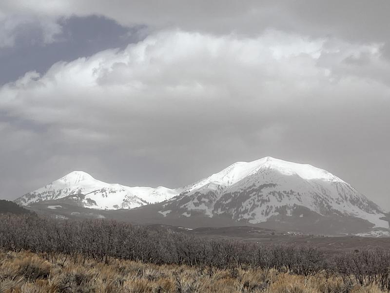
The southeast sides of Mounts Tukuhnikivatz (left) and Peale.
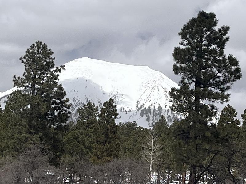
Upper slopes on the SE face of Mount Peale (12,700').
Snowpack and Weather Data
Gold Basin Storm Stake (10,000')
Gold Basin SNOTEL site (10,000')
SNOTEL site near Geyser Pass Winter Trailhead (9600')
Wind Station on Pre-Laurel Peak (11,400')
NWS forecast for the La Sal Mountains.
Recent Avalanches
Click here to see the La Sal avalanche database. Prudent backcountry travelers will want to know what slopes have previously avalanched, as some of these slopes hold shallow, weak snow.
Ad
Avalanche Problem #1
Wind Drifted Snow
Type
Location
Likelihood
Size
Description
There's very little snow available snow for transport out there but with wind speeds above 40 mph we still probably had some snow blowing around. Be on the lookout for shallow, fresh drifts on the leeward sides of ridge crests and terrain features primarily on upper elevation, northerly aspects.
Additional Information
Want some more insight into the La Sal Mountains as well as the communal impacts of a tragic avalanche? Check out the latest UAC podcast with forecaster Eric Trenbeath where he discusses the range, it's often treacherous snowpack, and how the devastating avalanche in February, 1992, affected the Moab community.
Our avalanche beacon checker sign and beacon training park are up and running. A huge thanks to Talking Mountain Yurts for sponsoring those this season!
Sign up for forecast region-specific text message alerts. You will receive messages about changing avalanche conditions, watches, warnings and road plowing closures.
Follow us on Instagram @utavy_moab
General Announcements
This forecast is from the U.S.D.A. Forest Service, which is solely responsible for its content. This forecast describes general avalanche conditions and local variations always occur.