

Observer Name
Trenbeath
Observation Date
Saturday, February 15, 2014
Avalanche Date
Saturday, February 8, 2014
Region
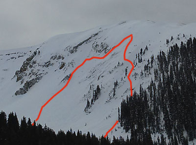
Moab » La Sal Mountains
Location Name or Route
Upper Horse Creek
Elevation
11,300'
Aspect
Northeast
Slope Angle
40°
Trigger
Natural
Avalanche Type
Soft Slab
Avalanche Problem
Wind Drifted Snow
Weak Layer
New Snow/Old Snow Interface
Depth
2'
Width
450'
Vertical
1,000'
Comments
Noticed rapid wind loading on this slope on February 8th, with sensitive cornices building. Additional snow load came in on February 9th which likely tipped the scales. Observed debris from above on the 13th, and skied in from below on the 15th to have a better look.
Coordinates