

Narrative as emailed by one of the party members:
We left from Alta and hiked to pole line pass. After skiing down into mill D south drainage we agreed and noticed that there we some wind loading and cracking near the ridge line and adjusted our plans to stay in more gentle terrain. We climbing the small dividing ridge that I do not know the name of. Near the top of this ridge we noticed a very small release about 100 feet away in the new snow about 4 inches deep. It seemed like a natural release but may have beet remotely trigged.
We skied the open trees toward the Cardiff Mine. From here we still agreed to make it towards our car parked at the base of mineral fork while staying away from higher entrances we chose to make the pass below high ivory. Following more the more benign terrain we found ourselves in the catch of getting to high too soon and then either having to ski down or climb the slight bench below ivory flakes. The desire for us not to descend on the climb got us into this area with a dangerous climb to the ridge. At this point we continued more or less spread out but all exposed to the bowl above.
As I was crossing what seemed to be the most exposed section, no longer in the run out but in an obvious gully mid slide path. It was approximately 11:50 am. I felt some collapsing and looking up a small slide descended on me washing past my waist and leaving me mid thigh in light snow that I was able to kick turn out of. When I turned around to check on the rest of my party I saw the large powder cloud descending behind the closest two members of my party. It seemed like the smaller slide I was in triggered the remainder of the bowl. The two members behind me were only slightly affected and the slide washed past them enveloping their legs. The three of us who were not carried or buried skied down two the two who were carried both about 100 feet and partially buried. They were about 2 feet apart and one had all but an arm buried and the other had all but a head and an arm buried. They were general on top of the snow and the debris was soft as we removed their skis (Both Dynafit in hiking mode and none releases in the slide) and removed them with some hand digging. Both of them complained of lower leg injuries one of soreness in both knees and the other of pain in the ankles especially the right one. They both decided to try skiing out. Everyone was ready to descend and 12:05 with all gear recovered. Only two poles needed some searching for. We were able to get everyone out skiing on their own power or assisted to ski down to Big Cottonwood Canyon road by 2:05pm .
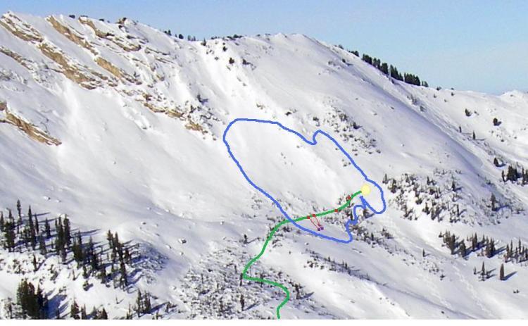
Photo is from a previous time but jus to show the location. The big yellow dot is where I was and likely trigged the avalanche. The other red dots are the other members of my party when the slide occurred. The red lines are for those who were carried and purple dots are where they were found partially buried. The blue line is the approximate slide area. There was no obvious crown line and the upper boundary of the slide is mostly guesswork. The larges deposition was between skiers 2 and 3 from the bottom and was probably 1.5 to 2 meters deep.