Forecast for the Uintas Area Mountains

Craig Gordon
Issued by Craig Gordon for
Saturday, December 6, 2014

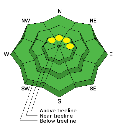
While not widespread, pockets of MODERATE avalanche danger exist on steep, upper elevation slopes facing the north half of the compass and human triggered avalanches are possible. Remember- triggering even a small slide will expose stumps and rocks, instantly ruing your day and quite possibly your season.

Out of the wind zone the avalanche danger is generally LOW.

Low
Moderate
Considerable
High
Extreme
Learn how to read the forecast here
Special Announcements

We just released an exciting, new avy safety video designed specifically for snowmobilers - Knowledge is Powder. https://vimeo.com/113677686

Wasatch County Search and Rescue is hosting an open house today with an avalanche awareness presentation by the UAC at 6:00. More details here.

Our Uinta weather station network is up and running. Current winds, snowfall, and temperatures can be found here.

NEW THIS YEAR: You can now receive advisories by email for each region in the state. Go here for details.

Weather and Snow

Skies are overcast, temperatures are in the low to mid 20's, and southerly winds are blowing 10-20 mph along the high ridges.

Ted took a spin up the Whitney Road yesterday. His most excellent rip report is found here.

It may look white from a distance, but lots of obstacles lurk just below the snow surface.

Recent Avalanches

No recent avalanche activity to report.

Ad
Avalanche Problem #1
Persistent Weak Layer
Type
Location
Likelihood
Size
Description

Today's avalanche conditions are pretty straight-forward and mostly predictable. You'd really have to go out of your way to trigger an avalanche this weekend. I think you run a better chance of slamming into a buried rock or stump. However, the Uinta's are a big place and as always, you'll want to look for and avoid any fresh wind drift, especially if it's fat and rounded or sounds hollow like a drum.

Additional Information

Look for a scattered snow flurry or two today as a weak storm system grazes the region. Skies will be mostly cloudy, temperatures climb into the mid 30's, and southwest winds blow 15-30 mph along the high peaks. High pressure returns for Sunday through midweek. Computer models suggest a glimmer of hope for a pattern change late next week.... we'll keep you posted.

General Announcements

Remember your information can save lives. If you see anything we should know about, please participate in the creation of our own community avalanche advisory by submitting snow and avalanche conditions. You can call me directly at 801-231-2170, email [email protected], or email by clicking HERE

This is a great time of year to schedule a free avalanche awareness presentation for your group or club. You can contact me at 801-231-2170 or email [email protected]

Donate to your favorite non-profit –The Utah Avalanche Center. The UAC depends on contributions from users like you to support our work.

Benefit the Utah Avalanche Center when you buy or sell on ebay - set the Utah Avalanche Center as a favorite non-profit in your ebay account here and click on ebay gives when you buy or sell. You can choose to have your seller fees donated to the UAC, which doesn't cost you a penny.

Utah Avalanche Center mobile app - Get your advisory on your iPhone along with great navigation and rescue tools.

The information in this advisory is from the US Forest Service which is solely responsible for its content. This advisory describes general avalanche conditions and local variations always occur.

I will update this advisory by 7:00 AM Sunday Dec. 7, 2014.