Forecast for the Uintas Area Mountains

Craig Gordon
Issued by Craig Gordon for
Sunday, December 14, 2014

In the wind zone at and above treeline a MODERATE avalanche danger exists and human triggered avalanches are possible on steep slopes facing the north half of the compass. Remember- triggering even a small slide will expose stumps and rocks, instantly ruing your day and quite possibly your season.

All other terrain offers a LOW avalanche danger.

Low
Moderate
Considerable
High
Extreme
Learn how to read the forecast here
Special Announcements

Huge thanks to Weller Recreation and Ski-Doo for partnering with The Avalanche Center and providing a loaner sled for the 2014-15 season. This partnership allows us to see more terrain, issue more accurate forecasts, and ultimately save more lives.

We just released an exciting, new avy safety video designed specifically for snowmobilers - Knowledge is Powder. https://vimeo.com/113677686

Our Uinta weather station network is up and running. Current winds, snowfall, and temperatures can be found here.

NEW THIS YEAR: You can now receive advisories by email for each region in the state. Go here for details.

Weather and Snow

We'll take what we can get. A couple more inches of snow fell overnight, bringing storm totals to 4" across the range. Winds backed off right around noon yesterday and have been light and variable since. Temperatures are in the low to mid teens.

Riding and turning options are pretty hit or miss. Shady terrain offers thin, yet mostly supportable conditions. Swing around to the sunny slopes and you're left high and dry on may slopes. Ted was in Millcreek Friday and his trip report is found here.

Recent Avalanches

No recent avalanche activity to report.

Ad
Avalanche Problem #1
Persistent Weak Layer
Type
Location
Likelihood
Size
Description

Friday's strong winds formed stout slabs on upper elevation leeward terrain. These fat, rounded drifts are resting on weak, sugary surface snow or if you really wanna geek out it's what snow nerds call near surface facets. In either case, today's drifts are now covered over with fresh snow and may be a little hard to detect. None-the-less, they'll still be reactive to the additional weight of a rider today. The most likely terrain to trigger a slide will be on upper elevation shady slopes, especially those facing the north half of the compass. Loose a little elevation, get out of the wind zone, and the avalanche danger decreases dramatically.

Here's a great snowpit that JG submitted from Bald Mountain Pass, clearly showing the weak surface snow. JG's trip report from Thursday can be found here.

Additional Information

Mostly cloudy skies begin to thin out as the day progresses and short-lived high pressure takes hold. Temperatures climb into the low 20's before dipping into the teens and single digits overnight. Clear skies for early in the week before a series of weak storms slides through mid week. Nothing too big, but enough snow to keep things freshened up. A larger storm could be on tap for next weekend. We will know more for the midweek update.

General Announcements

Remember your information can save lives. If you see anything we should know about, please participate in the creation of our own community avalanche advisory by submitting snow and avalanche conditions. You can call me directly at 801-231-2170, email [email protected], or email by clicking HERE

This is a great time of year to schedule a free avalanche awareness presentation for your group or club. You can contact me at 801-231-2170 or email [email protected]

Donate to your favorite non-profit –The Utah Avalanche Center. The UAC depends on contributions from users like you to support our work.

Benefit the Utah Avalanche Center when you buy or sell on ebay - set the Utah Avalanche Center as a favorite non-profit in your ebay account here and click on ebay gives when you buy or sell. You can choose to have your seller fees donated to the UAC, which doesn't cost you a penny.

Utah Avalanche Center mobile app - Get your advisory on your iPhone along with great navigation and rescue tools.

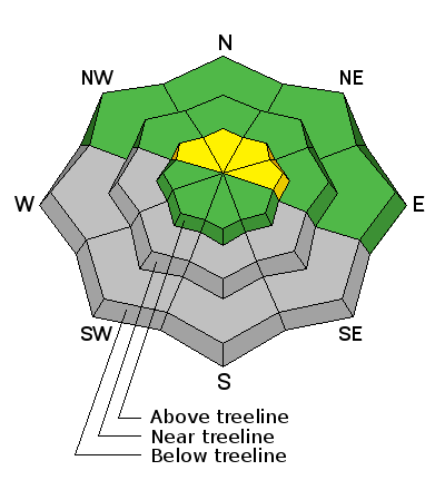
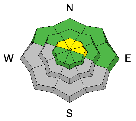
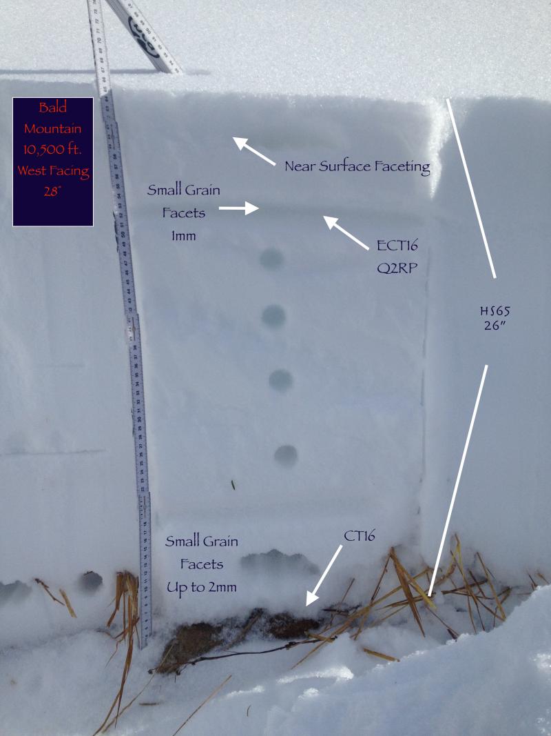
The information in this advisory is from the US Forest Service which is solely responsible for its content. This advisory describes general avalanche conditions and local variations always occur.

I will update this advisory by 7:00 AM Wednesday Dec. 17, 2014.