Forecast for the Skyline Area Mountains

Craig Gordon
Issued by Craig Gordon for
Saturday, December 13, 2014

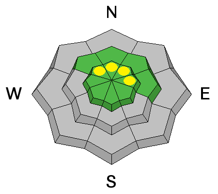
Pockets of MODERATE avalanche danger exist on steep wind drifted slopes and human triggered avalanches are possible.

Out of the wind zone the avalanche danger is generally LOW this weekend.

Low
Moderate
Considerable
High
Extreme
Learn how to read the forecast here
Special Announcements

We just released an exciting, new avy safety video designed specifically for snowmobilers - Knowledge is Powder. https://vimeo.com/113677686

Also, please join us today... Saturday Dec. 13th, at Big Pine Sports-


Weather and Snow

The winter that wasn't. The big California storm blew apart before reaching the Skyline and we've been robbed! Just a trace to an inch of snow fell overnight. Temperatures are in the upper 20's and southwest winds are blowing 10-25 mph along the high peaks. There's really not that much snow on the Skyline and riding and turning options are limited to rock-free grassy meadows and roads.

Recent Avalanches

No avalanche activity to report.

Ad
Avalanche Problem #1
Persistent Weak Layer
Type
Location
Likelihood
Size
Description

You'd really have to go out of your way to trigger an avalanche today, but the Skyline is a big place and I bet a fresh wind drift or two lurks in steep, upper elevation terrain facing the north half of the compass.

Remember- there's not much snow and triggering a slide will immediately ruin your day, taking you for a nasty ride through rocks and stumps barely hidden underneath the shallow snowpack, resulting in a season ending injury.

Additional Information

A few scattered snow showers are still on tap for the region, but I think the main event went by us with little fanfare. Southwest winds will relax as the day progresses and skies should begin to clear. Temperatures climb into the low 30's and overnight lows dip into the upper teens and low 20's. Not much change in the overall weather pattern. Two weak systems are slated to slide through the region.... one midweek, the other next weekend.

General Announcements

We're still interested in snow and avalanche information. If you see anything we should know about, please participate in the creation of our own community avalanche advisory by submitting snow and avalanche conditions. You can call me directly at 801-231-2170, email [email protected], or email by clicking HERE

Donate to your favorite non-profit –The Utah Avalanche Center. The UAC depends on contributions from users like you to support our work.

Benefit the Utah Avalanche Center when you buy or sell on ebay - set the Utah Avalanche Center as a favorite non-profit in your ebay account here and click on ebay gives when you buy or sell. You can choose to have your seller fees donated to the UAC, which doesn't cost you a penny.

Utah Avalanche Center mobile app - Get your advisory on your iPhone along with great navigation and rescue tools.

The information in this advisory is from the US Forest Service which is solely responsible for its content. This advisory describes general avalanche conditions and local variations always occur.

I will update this advisory by 7:00 AM Saturday Dec. 20, 2014.