Forecast for the Salt Lake Area Mountains

Drew Hardesty
Issued by Drew Hardesty for
Wednesday, December 3, 2014

An overall MODERATE danger exists in the backcountry for human triggered slides 1-3' deep and a couple hundred feet wide. These Low-Probability/High-Consequence bone-snappers are found predominantly on west to north to east facing slopes above 9-9500'. Cornice drops, previous tracks, and slope cuts tend to provide little to no information for these conditions. These slides may also be triggered at a distance. The danger associated with any new snow and wind may rise toward Moderate but will be generally harmless and short-lived.

Low
Moderate
Considerable
High
Extreme
Learn how to read the forecast here
Special Announcements

On December 4, Powderwhore Productions will be bringing Some Thing Else to Park City. A fundraising raffle will be held to benefit the Utah Avalanche Center. Details here.

According to legend, the late alpinist and - for one season anyway - Utah Avalanche Center forecaster Alex Lowe (with a nod to the surf-scene) pioneered the term "Dawn Patrol" for getting up and out at Oh-Dark-30 to ski a few lines in the backcountry before work. If you're heading out early these days, tune in to our Dawn Patrol hotline 888-999-4019 option 8. Generally loose and, uh, unscripted, we record it daily between 5 and 530am.

You may have already seen this, but Black Diamond Equipment and Powder Magazine have embarked on a phenomenal project to look into the Human Factor - that is, how we as humans perceive and approach Risk...and what pitfalls or traps lie in wait for us. It's a fascinating project. BD continues this look at RISK in the alpine and winter backcountry environment by interviewing a number of folks, including climbers Alex Honnold, Conrad Anker, UAC director Bruce Tremper and some other guy they found sweeping the floor in the back.

Weather and Snow

Skies are overcast, temps hover in the upper 20s, and the winds now blow from the south and southeast ahead of today's swing-and-a-miss storm. Average wind speeds along the ridgelines are in the 20-30mph range, but I suspect they'll nod off a touch as the day wears on. Total snow depths are roughly 1-3' in the central Wasatch and about half that in the Ogden and Provo area mountains. Snow surface conditions are something only a mother could love.

Recent Avalanches

None. Last backcountry human triggered slide was on Saturday.

Ad
Avalanche Problem #1
New Snow
Type
Location
Likelihood
Size
Description

As the weak basal facets and developing depth hoar adjust to the load of the Nov 22-24 storm, obvious clues such as cracking and collapsing become less common and all we're left with is looking at the same structure of 1-3' of strengthening slab over 3-6" of weak grains. It's all about structure - strong over weak = red flag...........weak over strong = ski it if it's white (or snowshoe it if it's white - insert your choice of equipment). To be sure, this oversimplifies the situation, but snow tests continue to provide incriminating evidence that although it may be increasingly difficult to trigger a slide, it is likely to rip out at or near the ground. Snow profile and photo from Todd Leeds below.

Avalanche Problem #2
New Snow
Type
Location
Likelihood
Size
Description

While the icon says "Storm Snow", in this case I'm using it as a "catch-all" for shallow sluffs and new wind drifts that may bond poorly to the 1-2" of snow from Sunday. These are predominantly on west to north to east facing upper elevation and easily manageable hazards for experienced hands.

Additional Information

The storm off the west coast with a sub-tropical moisture tap has already begun to bring moisture into the state, but it's centered on southern Utah...with pieces of it moving by to the north. The weather model below tells the story. In any event, winds will be from the south and southwest, blowing 20-25mph and gradually veering to the west and losing steam over the next couple days. Temps will rise from the upper 20s at 10,000' to near freezing by tonight. Snow totals look to be in the 2-4" range if we're lucky. A dirty ridge (weather slang to imply a ridge of high pressure with moisture and clouds that occasionally drift through) builds for the foreseeable future.

General Announcements

Remember your information can save lives. If you see anything we should know about, please participate in the creation of our own community avalanche advisory by submitting snow and avalanche conditions. You can also call us at 801-524-5304, email by clicking HERE, or include #utavy in your tweet or Instagram.

If you trigger an avalanche in the backcountry - especially if you are adjacent to a ski area – please call the following teams to alert them to the slide and whether anyone is missing or not. Rescue teams can be exposed to significant hazard when responding to avalanches, and do not want to do so when unneeded. Thanks.

Salt Lake and Park City – Alta Central (801-742-2033), Canyons Resort Dispatch (435-615-3322)

Snowbasin Resort Dispatch (801-620-1017), Powder Mountain Dispatch (801-745-3772 x 123).

Sundance Dispatch (801-223-4150)

EMAIL ADVISORY If you would like to get the daily advisory by email you will need to subscribe here.​

DAWN PATROL Hotline updated daily by 5-530am - 888-999-4019 option 8.

Twitter Updates for your mobile phone - DETAILS

UDOT canyon closures: LINK TO UDOT

Utah Avalanche Center mobile app - Get your advisory on your iPhone along with great navigation and rescue tools.

Wasatch Powderbird Guides Blog/Itinerary for the Day.

Lost or Found something in the backcountry? - http://nolofo.com/

Ski Utah mobile snow updates

Discount lift tickets will soon be available at Backcountry.com - Thanks to Ski Utah and the Utah Resorts. All proceeds go towards paying for Utah Avalanche Center avalanche and mountain weather advisories.

To those skinning uphill at resorts: it is your responsibility to know the resort policy on uphill travel. You can see the uphill travel policy for each resort here. IMPORTANT: Before skinning or hiking at a resort under new snow conditions, check in with Ski Patrol. Resorts can restrict or cut off access if incompatible with control and grooming operations.

Benefit the Utah Avalanche Center when you shop from Backcountry.com or REI: Click this link for Backcountry.com or this link to REI, shop, and they will donate a percent of your purchase price to the UAC. Both offer free shipping (with some conditions) so this costs you nothing!

Benefit the Utah Avalanche Center when you buy or sell on ebay - set the Utah Avalanche Center as a favorite non-profit in your ebay account here and click on ebay gives when you buy or sell. You can choose to have your seller fees donated to the UAC, which doesn't cost you a penny.

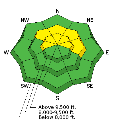
This information does not apply to developed ski areas or highways where avalanche control is normally done. This advisory is from the U.S.D.A. Forest Service, which is solely responsible for its content. This advisory describes general avalanche conditions and local variations always exist.