Forecast for the Moab Area Mountains

Eric Trenbeath
Issued by Eric Trenbeath for
Saturday, December 13, 2014

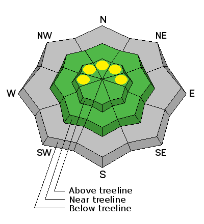
The avalanche danger is generally LOW this morning but could rise to MODERATE later in the day on upper elevation slopes in wind exposed terrain that have a W-N-E aspect. Watch for isolated wind slab development on the lee sides off terrain features.

Low
Moderate
Considerable
High
Extreme
Learn how to read the forecast here
Weather and Snow

Mountain weather conditions at 11,700' on Pre-Laurel Peak.

Snow totals at Geyser Pass Trailhead.

Temperatures have been dropping since midnight as a cold front from an approaching pacific storm system moves into the Four Corners region. SSE winds have been blowing in the 20-30 mph range overnight with gusting near 50 mph. It is currently 24 degrees on Pre Laurel Peak and 34 degrees at the Geyser Pass Trailhead.

Generally low snow conditions prevail with about 10" on the ground at the Geyser Pass Trailhead, and 20" in Gold Basin. Many wind and sun exposed slopes are scoured or melted off down to the rocks and the existing snow surface is a mixed bag of crusts and facets. We may 6"-10" of snow from this storm which will be an improvement, but it won't be quite enough to make it game on yet. In addition, expect the new snow to hide many obstacles such as stumps and rocks. Caaution and tempering enthusiasm is advised.

Ad
Avalanche Problem #1
Persistent Weak Layer
Type
Location
Likelihood
Size
Description

Look for new wind slab development later in the day as snow begins to accumulate on upper elevation, wind exposed terrain with a W-N-E aspect. Deposits will e shallow, and without much other snow available for transport, will pose little threat. But this danger could increase, especially by tomorrow, if we receive the upper end off forecasted snow amounts.

Additional Information

Snow showers should be begin today and extend into Sunday morning as a fast moving storm system moves through the Four Corners region.

Today: Snow showers. High near 43. Breezy, with a west southwest wind 15 to 20 mph decreasing to 5 to 10 mph in the afternoon. Winds could gust as high as 30 mph. Chance of precipitation is 100%. Total daytime snow accumulation of 3 to 5 inches possible.

Tonight: Snow. Low around 15. West southwest wind 5 to 10 mph increasing to 10 to 15 mph after midnight. Chance of precipitation is 100%. New snow accumulation of 3 to 5 inches possible.

Sunday: Snow likely, mainly before 11am. Cloudy, then gradually becoming mostly sunny, with a high near 27. North northwest wind around 10 mph. Chance of precipitation is 60%. New snow accumulation of 1 to 2 inches possible.

Sunday Night: Partly cloudy, with a low around 14. Northwest wind 5 to 10 mph.

Monday: Mostly sunny, with a high near 30. North northeast wind 5 to 10 mph becoming southwest in the afternoon.

Monday Night: Mostly cloudy, with a low around 17.

Tuesday: Mostly cloudy, with a high near 29.

Tuesday Night: A chance of snow. Cloudy, with a low around 16.

Wednesday: A chance of snow. Cloudy, with a high near 26.

Wednesday Night: A chance of snow. Cloudy, with a low around 14.

Thursday: A chance of snow. Mostly cloudy, with a high near 25.

Thursday Night: Mostly cloudy, with a low around 14.

Friday: Mostly sunny, with a high near 28.

General Announcements

The Geyser Pass Road is currently a sheet of ice in many areas, and with the addition of new snow, 4wd will be required to reach the trailhead.

There will be a volunteer trail grooming clinic sponsored by the Lower Utah Nordic Alliance (LUNA), in partnership with the Manti-La Sal National Forest, on Saturday, December 13. A one hour session at 8:00 a.m. at the Moab Arts and Recreation Center will be followed by hands on instruction at the Geyser Pass Trailhead. For more information contact Kirsten Peterson at 435-260-0042.