Forecast for the Logan Area Mountains

Toby Weed
Issued by Toby Weed for
Friday, December 5, 2014

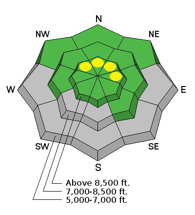
There's a LOW (level 1) danger and the snow is stable on most slopes in the Logan Zone. Exceptions and pockets of heightened or MODERATE (level 2) danger can be found on some drifted upper elevation slopes and in isolated or outlying areas with poor snow structure. Evaluate the snow and terrain carefully, continue to use safe travel protocols, and practice regularly with your rescue equipment.

Low
Moderate
Considerable
High
Extreme
Learn how to read the forecast here
Special Announcements

Come check out White Waves----A free screening for Jeremy Jensen's MFA Film Project. Tonight, (Friday) 7:00 - 9:00 at the Taggart Student Center at Utah State University

Weather and Snow

This morning at the 8400' Tony Grove Snotel, it's 32 degrees and there's 34 inches of total snow containing 140% of average water for the date. The 9700' CSI Logan Peak weather station is recording west winds averaging less than 10 mph. The coverage is quite good above around 8000', with the heavy snows from November nicely filling in the rocky terrain. You can ride just about anywhere without sinking in too deeply and you can see the larger protruding rocks, but I found ascending on skis difficult in places because of a slippery rime-crust beneath a few inches of mashed potato-like snow. Here's my Video Observation from the White's Bedground Area on Wednesday.


Be sure your rescue gear is functioning by practicing with it, and force your partners to join in. It is they who will be your best bet for survival if you get caught in an avalanche. The Tony Grove road is not maintained for wheeled travel in the winter!

Recent Avalanches

No recent avalanches to report in the Logan Zone.... Visit our Backcountry Observations Page for details


Ad
Avalanche Problem #1
Wind Drifted Snow
Type
Location
Likelihood
Size
Description

Although certainly not widespread, pockets with heightened avalanche conditions exist, and triggered avalanches are possible in some upper elevation terrain. Avoid deposits of drifted snow on the lee side of major ridges and areas where snow has been deposited into gullies or below cliff bands by strong winds. There may be very steep isolated slopes on the highest peaks where one could trigger a deeper persistent slab avalanche. The highest smooth slopes with snow cover in early November are suspect, but we've found a few shallower areas at upper elevations with weak sugary or faceted snow and a thin mid-pack weak layer consisting of small grained facets and graupel in some areas.

Additional Information

There's a chance of a few snow showers this morning, but the sun should come out this afternoon and high temperatures at 8500' are forecast to reach 36 degrees. Expect light southwest winds. We'll see a 20 % chance of snow tomorrow, mostly cloudy skies, a high temperature around 37 degrees and slightly increasing southwest winds.. Similar weather conditions will persist through most of next week, with only a hint of the next Pacific storm and a deep trough of Low Pressure at the extent of the forecast period and a week or so out....

Check out our one-stop weather page........HERE

General Announcements

Big THANKS to our support and to YOU for coming to our Pray for Snow fundraiser. You made the party a huge success!

Backcountry 101 Avalanche Class! Register now for our first on-snow class of the season. Thursday evening December 11 and all day Saturday December 13. http://utahavalanchecenter.org/classes/backcountry-101-4

You can now receive advisories by email for each region in the state. Go here for details.

Get your advisory on your iPhone along with great navigation and rescue tools....... Utah Avalanche Center mobile app

Please submit snow and avalanche observations from your ventures in the backcountry HERE. You can call us at 801-524-5304 or email HERE, or include #utavy in your Instagram or Tweet us @UAClogan . To report avalanche activity in the Logan Area or to contact the local avalanche forecaster call me, Toby, at 435-757-7578.

I'll regularly update this advisory on Monday, Wednesday, Friday, and Saturday mornings by about 7:30. This advisory is produced by the U.S.D.A. Forest Service, which is solely responsible for its content. It describes only general avalanche conditions and local variations always exist.