Forecast for the Logan Area Mountains

Toby Weed
Issued by Toby Weed for
Friday, November 28, 2014

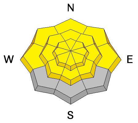
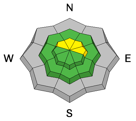
Heightened avalanche conditions exist in the backcountry, and there's a MODERATE or level 2 danger. Triggered loose wet avalanches are possible today on steep slopes with saturated snow, and you might trigger wind slab avalanches on isolated drifted upper elevation slopes. Evaluate the snow and terrain carefully, continue to use safe travel protocols, and practice regularly with your rescue equipment.

Low
Moderate
Considerable
High
Extreme
Learn how to read the forecast here
Special Announcements

We look forward to seeing you at our annual fundraiser party at the Italian Place in Logan on Wednesday evening, December 3... We very much need and value your support.

Weather and Snow

There's 35 inches of total snow this morning, containing 163% of average water for the date, and a balmy temperature of 41 degrees at the 8400' Tony Grove Snotel. It's 35 degrees at 9700', and the CSI Logan Peak weather station is recording southwest winds averaging in the upper twenties. We're seeing fairly good stability so far locally. Perhaps we're lucky not to have had any snow on the ground in early November. Upper elevation slopes in the Central Bear River Range now have 3 to 4 feet of snow where there was none before the 11/14 storm. The snow is saturated at mid and lower elevations and crusts will develop in most areas with cooling.

The Tony Grove road is not maintained for wheeled travel in the winter!

Recent Avalanches

No avalanches were recently reported in the Logan Zone, but it's still active and dangerous in the Central Wasatch Range. A backcountry skier in Big Cottonwood Canyon triggered and managed to escape a large hard slab avalanche yesterday.

Visit our Backcountry Observations Page for details


Ad
Avalanche Problem #1
Wet Snow
Type
Location
Likelihood
Size
Description

Very warm temperatures again in the mountains may help stability in the long term, but are melting off low elevation snow and creating slushy snow conditions up higher. Heightened wet avalanche conditions exist on steep slopes with saturated snow, and loose wet avalanches or sluffs are possible. Avoid steep slopes above terrain traps like trees or gullies..

Avalanche Problem #2
Persistent Weak Layer
Type
Location
Likelihood
Size
Description

Triggered wind slab avalanches are possible in isolated exposed upper elevation terrain. Very steep slopes on the highest peaks are suspect. Avoid hard deposits of drifted snow on the lee side of major ridges and areas where snow has been deposited into gullies of below cliff bands by the recent strong winds.

Additional Information

It'll be windy and warm again today in the mountains, with partly sunny skies and a high forecast high temperature of 47 degrees at 8500' and 20-30 mph southwest winds, with gusts near 50 mph in some exposed areas. Looks like snow for the weekend....1 to 2 inches of accumulation tomorrow, 2 to 4 tomorrow night, and 3 to 5 on Sunday. We should remain in an active pattern next week with nothing overly impressive in sight.

Check out our one-stop weather page........HERE

General Announcements

Don't forget our annual fundraiser party at the Italian Place in Logan on Wednesday evening, December 3...

Backcountry 101 Avalanche Class coming up! Register now for our first on-snow class of the season. Thursday evening December 11 and all day Saturday December 13. The season is upon us and the time is now to learn how to stay safe in the backcountry. http://utahavalanchecenter.org/classes/backcountry-101-4

NEW THIS YEAR: You can now receive advisories by email for each region in the state. Go here for details.

Utah Avalanche Center mobile app - Get your advisory on your iPhone along with great navigation and rescue tools.

Remember your information can save lives. If you see anything we should know about, please participate in the creation of our own community avalanche advisory by submitting snow and avalanche conditions. You can also call us at 801-524-5304 or 800-662-4140, email by clicking HERE, or include #utavy in your Instagram.

Follow us at UAClogan on Twitter

This advisory is produced by the U.S.D.A. Forest Service, which is solely responsible for its content. It describes only general avalanche conditions and local variations always exist.