Forecast for the Logan Area Mountains

Toby Weed
Issued by Toby Weed for
Monday, November 24, 2014

Dangerous avalanche conditions exist in the backcountry, and there's a CONSIDERABLE or level 3 danger. You could trigger dangerous avalanches on slopes steeper than about 30 degrees. Avoid drifted upper elevation terrain and steep slopes with significant recent accumulations on preexisting snow cover.

Low
Moderate
Considerable
High
Extreme
Learn how to read the forecast here
Avalanche Warning

THE AVALANCHE WARNING FOR ALL MOUNTAINS OF NORTHERN UTAH WILL CONTINUE THROUGH MIDWEEK. DANGEROUS AVALANCHE CONDITIONS EXIST AT THE MID AND UPPER ELEVATIONS...WITH BOTH NATURAL AND HUMAN TRIGGERED SLIDES LIKELY. THIS WARNING DOES NOT INCLUDE SKI AREAS OR HIGHWAYS WHERE AVALANCHE CONTROL IS NORMALLY DONE.

Special Announcements

We look forward to seeing you at our annual fundraiser party at the Italian Place in Logan on December 3...

Weather and Snow

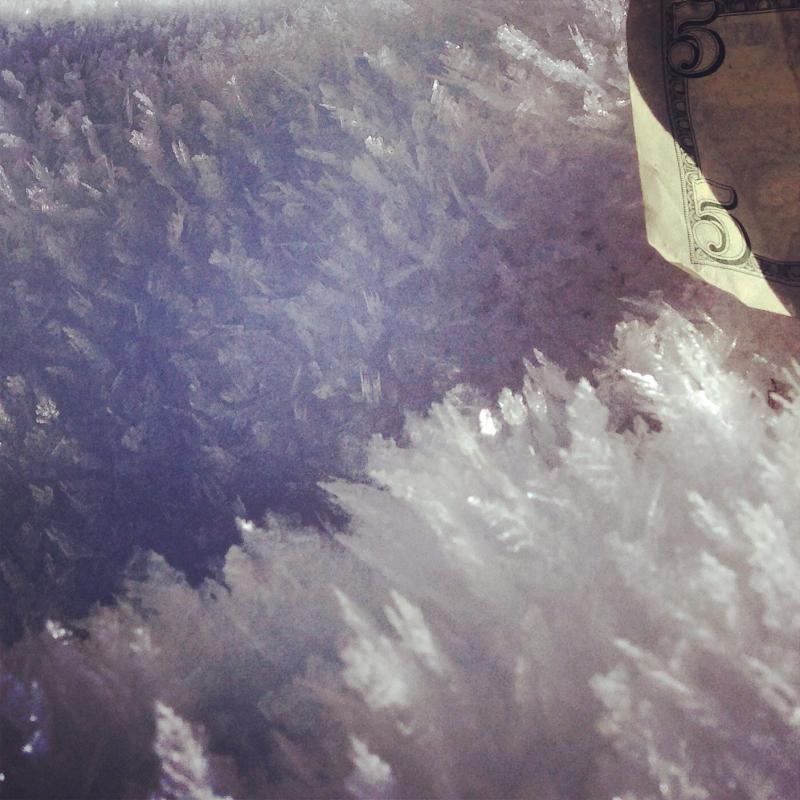
There's 40 inches of total snow this morning, containing 157% of average water for the date, and a temperature of 19 degrees at the 8400' Tony Grove Snotel. The station reports around 2 feet of new snow containing 2.7 inches of water in the last 48 hrs. West winds are currently averaging in the mid thirties with gusts in the 40's on Mt Ogden. It's also fairly windy at the Hwy 89 Logan Summit weather station, with west-northwest winds gusting into the 40 mph range and it's 21 degrees Last weekend's snow was showing the effects of a strong temperature gradient and resulting sublimation, and we observed frost or surface hoar crystals in some sheltered areas. Limited reports from the backcountry indicate lots of new snow, some collapsing, and "droppy" conditions. The Tony Grove road is not maintained for wheeled travel in the winter!

11-22-2014, Wind plume coming off Wellsville Cone during brief period with good visibility yesterday afternoon. (Pagnucco)

Recent Avalanches

No avalanches were yet reported this season in the Logan Zone, but it was very active in the Central Wasatch Range yesterday.

Visit our Backcountry Observations Page for details


Ad
Avalanche Problem #1
Persistent Weak Layer
Type
Location
Likelihood
Size
Description

Triggered wind slab avalanches are likely in exposed terrain this morning. Strong south and west winds during the storm and northwest winds overnight occurred during periods of heavy snowfall causing significant loading in lee slope deposition zones. The drifted snow will be stiffer than the fresh powder, but might still be soft and rather undetectable. Otherwise obvious wind slabs might be hidden by a bit of capping fresh powder. Expect sensitive or perhaps stubborn wind slabs on the lee sides of ridge-lines and in and around terrain features like rock outcroppings, sub-ridges and gullies. Fresh wind slabs could be 2 feet deep in places and they could be fairly wide, depending on terrain.

Avalanche Problem #2
New Snow
Type
Location
Likelihood
Size
Description

The weekend storm created dangerous conditions in the backcountry, with heavy snow, strong winds, and rapid accumulations on preexisting weak snow. In places the fresh slab could fail on last week's snow surface consisting of sugary faceted snow and/or feathery surface hoar. Dangerous storm slab avalanche conditions exist today on steep slopes, and the now buried persistent weak layers that are notoriously slow to heal will continue to be of concern for a while.

Feathers of Surface Hoar or frost like these in Wood Camp Hollow can become a persistent weak layer if buried intact.

Additional Information

Snowfall should continue at times through this morning. It'll be mostly cloudy in the mountains with temperatures in the mid to lower twenties and fairly strong and gusty northwest winds. 1 to 3 inches of additional snowfall is possible during the day today.. Temperatures will drop into the mid teens and northwest winds will continue, bringing the wind chill below zero. More snow is likely tomorrow and west-northwest winds will continue as another wave of Pacific storminess passes overhead. Looks like the weather will improve midweek in time for the Thanksgiving holiday.

Check out our one-stop weather page........HERE

General Announcements

NEW THIS YEAR: You can now receive advisories by email for each region in the state. Go here for details.

Utah Avalanche Center mobile app - Get your advisory on your iPhone along with great navigation and rescue tools.

Remember your information can save lives. If you see anything we should know about, please participate in the creation of our own community avalanche advisory by submitting snow and avalanche conditions. You can also call us at 801-524-5304 or 800-662-4140, email by clicking HERE, or include #utavy in your Instagram.

Follow us at UAClogan on Twitter

This advisory is produced by the U.S.D.A. Forest Service, which is solely responsible for its content. It describes only general avalanche conditions and local variations always exist.