Forecast for the Logan Area Mountains

Toby Weed
Issued by Toby Weed for
Sunday, November 23, 2014

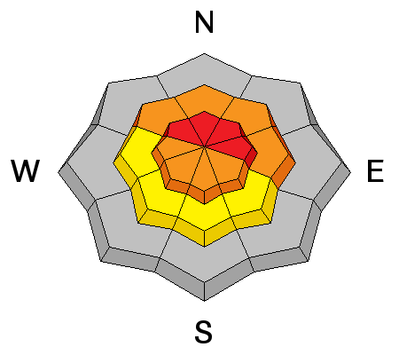
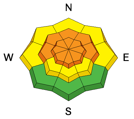
Dangerous avalanche conditions exist and there's a HIGH or level 4 danger on drifted upper elevation slopes. Natural and triggered wind slab and storm snow avalanches are likely. The danger in sheltered terrain and at mid elevations is a level 3 or CONSIDERABLE, and you could trigger dangerous avalanches in steep terrain. Avoid drifted upper elevation avalanche terrain and steep slopes with significant accumulations of new storm snow.

Low
Moderate
Considerable
High
Extreme
Learn how to read the forecast here
Avalanche Warning

THE AVALANCHE WARNING FOR ALL MOUNTAINS OF NORTHERN UTAH HAS BEEN CONTINUED THROUGH 5 AM MONDAY. DANGEROUS AVALANCHE CONDITIONS EXIST AT THE MID AND UPPER ELEVATIONS...WITH BOTH NATURAL AND HUMAN TRIGGERED SLIDES LIKELY. THIS WARNING DOES NOT INCLUDE SKI AREAS OR HIGHWAYS WHERE AVALANCHE CONTROL IS NORMALLY DONE.

Special Announcements

We look forward to seeing you at our annual fundraiser party at the Italian Place in Logan on December 3...

Weather and Snow

There's 35 inches of total snow this morning, containing 150% of average water for the date, and a temperature of 20 degrees at the 8400' Tony Grove Snotel. The station reports 15 inches of new snow containing 2.1 inches of water. Northwest winds are currently averaging in the lower teens with gusts in the 20's at the Hwy 89 Logan Summit weather station and it's 20 degrees Last weekend's snow was showing the effects of a strong temperature gradient and resulting sublimation, and we observed frost or surface hoar crystals in some sheltered areas.

The Tony Grove road is not maintained for wheeled travel in the winter!

11-22-2014, Wind plume coming off Wellsville Cone during brief period with good visibility yesterday afternoon. (Pagnucco)

Recent Avalanches

No avalanches were yet reported this season in the Logan Zone, but it was active in the Wasatch last weekend.

Visit our Backcountry Observations Page for details


Ad
Avalanche Problem #1
Persistent Weak Layer
Type
Location
Likelihood
Size
Description

Triggered and natural wind slab avalanches are likely in exposed terrain this morning. Strong southwest winds yesterday and northwest winds overnight occurred during periods of heavy snowfall causing significant loading in lee slope deposition zones. The drifted snow will be a bit stiffer than the powder in more sheltered areas, but could still be soft and rather undetectable. Expect sensitive wind slabs on the lee sides of ridge-lines and in and around terrain features like rock outcroppings, sub-ridges and gullies and near ridge lines. Fresh wind slabs could be 2 to 3 feet deep in places and they could be fairly wide, depending on terrain.

Avalanche Problem #2
New Snow
Type
Location
Likelihood
Size
Description

Yesterday's storm created dangerous conditions in the backcountry, with heavy snow, strong winds, and rapid accumulations on preexisting weak snow. In places yesterday's heavy new snow will probably not stick so well to last week's snow surface consisting of sugary faceted snow and feathery surface hoar. Dangerous storm slab avalanche conditions exist today on many steep slopes. Natural storm slab avalanches are possible and triggered avalanches are likely.

Feathers of Surface Hoar or frost like these in Wood Camp Hollow can become a persistent weak layer if buried intact.

Additional Information

Snowfall should continue at times through today and intensify again tonight, with another foot or so possible then. It'll be mostly cloudy in the mountains with temperatures in the mid to lower teens and fairly strong and gusty northwest winds. 1 to 3 inches of additional snowfall is possible during the day today.. Winds will shift from the west this evening as another cold front slams into the mountains, with 5 to 9 additional inches of accumulation forecast.

Check out our one-stop weather page........HERE

General Announcements

NEW THIS YEAR: You can now receive advisories by email for each region in the state. Go here for details.

Utah Avalanche Center mobile app - Get your advisory on your iPhone along with great navigation and rescue tools.

Remember your information can save lives. If you see anything we should know about, please participate in the creation of our own community avalanche advisory by submitting snow and avalanche conditions. You can also call us at 801-524-5304 or 800-662-4140, email by clicking HERE, or include #utavy in your Instagram.

Follow us at UAClogan on Twitter

This advisory is produced by the U.S.D.A. Forest Service, which is solely responsible for its content. It describes only general avalanche conditions and local variations always exist.